You are here: Home > Network List > TA - USArray Transportable Network (new EarthScope stations) Stations List
> Station P59A Jarrettsville, MD, USA > Earthquake Result Viewer
P59A Jarrettsville, MD, USA - Earthquake Result Viewer
| Earthquake location: |
Near Coast Of Northern Chile |
| Earthquake latitude/longitude: |
-19.9/-70.6 |
| Earthquake time(UTC): |
2014/03/16 (075) 21:16:30 GMT |
| Earthquake Depth: |
20 km |
| Earthquake Magnitude: |
6.7 MWW, 6.7 MWC, 7.0 MI |
| Earthquake Catalog/Contributor: |
NEIC PDE/NEIC COMCAT |
|
| Network: |
TA USArray Transportable Network (new EarthScope stations) |
| Station: |
P59A Jarrettsville, MD, USA |
| Lat/Lon: |
39.61 N/76.43 W |
| Elevation: |
157 m |
|
| Distance: |
59.5 deg |
| Az: |
354.796 deg |
| Baz: |
173.657 deg |
| Ray Param: |
0.062143452 |
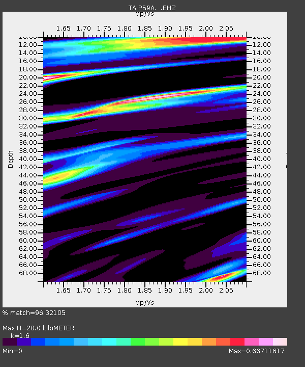
| Estimated Moho Depth: |
20.0 km |
| Estimated Crust Vp/Vs: |
1.60 |
| Assumed Crust Vp: |
6.419 km/s |
| Estimated Crust Vs: |
4.012 km/s |
| Estimated Crust Poisson's Ratio: |
0.18 |
|
| Radial Match: |
96.32105 % |
| Radial Bump: |
252 |
| Transverse Match: |
81.689575 % |
| Transverse Bump: |
400 |
| SOD ConfigId: |
626651 |
| Insert Time: |
2014-04-21 07:42:11.925 +0000 |
| GWidth: |
2.5 |
| Max Bumps: |
400 |
| Tol: |
0.001 |
|
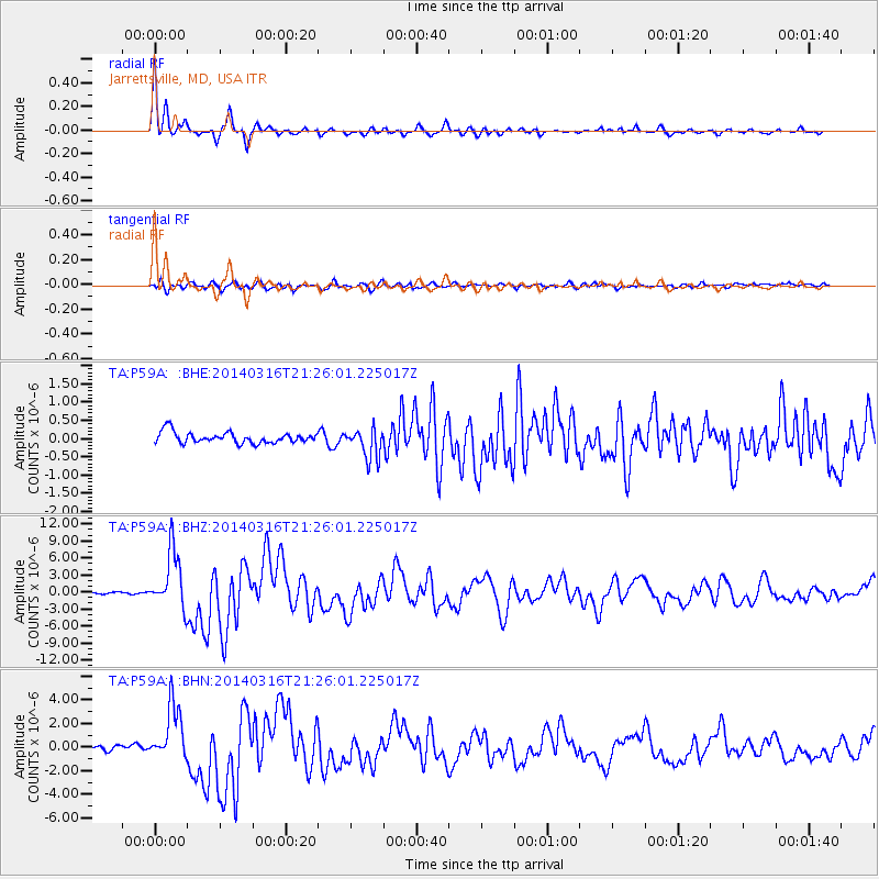
Signal To Noise
| Channel | StoN | STA | LTA |
| TA:P59A: :BHZ:20140316T21:26:01.225017Z | 26.227371 | 5.1192787E-6 | 1.951884E-7 |
| TA:P59A: :BHN:20140316T21:26:01.225017Z | 9.283322 | 2.405479E-6 | 2.5911834E-7 |
| TA:P59A: :BHE:20140316T21:26:01.225017Z | 2.8122852 | 4.1811404E-7 | 1.4867413E-7 |
| Arrivals |
| Ps | 2.0 SECOND |
| PpPs | 7.7 SECOND |
| PsPs/PpSs | 9.7 SECOND |


