You are here: Home > Network List > TA - USArray Transportable Network (new EarthScope stations) Stations List
> Station Q49A Aurora, IN, USA > Earthquake Result Viewer
Q49A Aurora, IN, USA - Earthquake Result Viewer
| Earthquake location: |
Near Coast Of Northern Chile |
| Earthquake latitude/longitude: |
-19.9/-70.6 |
| Earthquake time(UTC): |
2014/03/16 (075) 21:16:30 GMT |
| Earthquake Depth: |
20 km |
| Earthquake Magnitude: |
6.7 MWW, 6.7 MWC, 7.0 MI |
| Earthquake Catalog/Contributor: |
NEIC PDE/NEIC COMCAT |
|
| Network: |
TA USArray Transportable Network (new EarthScope stations) |
| Station: |
Q49A Aurora, IN, USA |
| Lat/Lon: |
39.01 N/84.90 W |
| Elevation: |
264 m |
|
| Distance: |
60.1 deg |
| Az: |
347.205 deg |
| Baz: |
164.489 deg |
| Ray Param: |
0.061716534 |
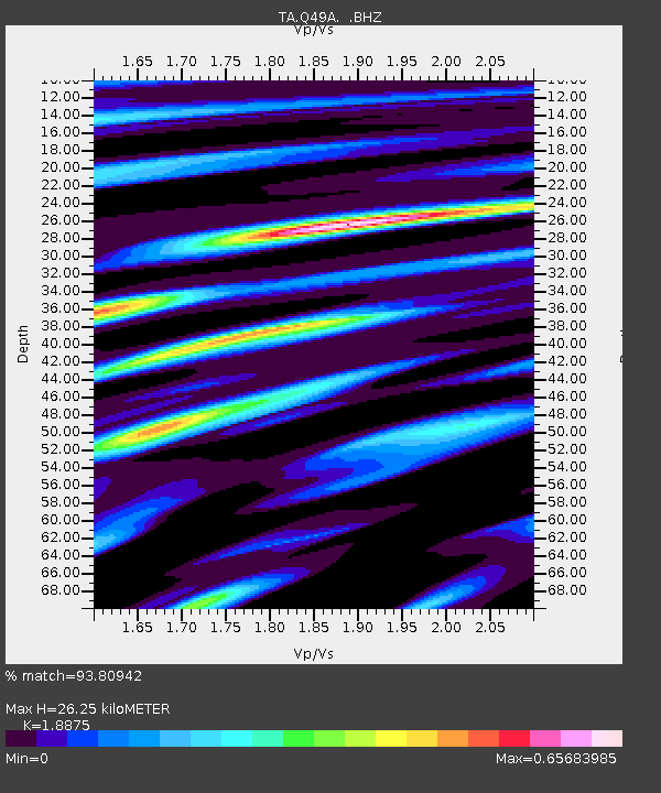
| Estimated Moho Depth: |
26.25 km |
| Estimated Crust Vp/Vs: |
1.89 |
| Assumed Crust Vp: |
6.498 km/s |
| Estimated Crust Vs: |
3.442 km/s |
| Estimated Crust Poisson's Ratio: |
0.30 |
|
| Radial Match: |
93.80942 % |
| Radial Bump: |
400 |
| Transverse Match: |
72.1675 % |
| Transverse Bump: |
400 |
| SOD ConfigId: |
626651 |
| Insert Time: |
2014-04-21 07:42:26.617 +0000 |
| GWidth: |
2.5 |
| Max Bumps: |
400 |
| Tol: |
0.001 |
|

Signal To Noise
| Channel | StoN | STA | LTA |
| TA:Q49A: :BHZ:20140316T21:26:05.699993Z | 22.144733 | 4.5417723E-6 | 2.0509492E-7 |
| TA:Q49A: :BHN:20140316T21:26:05.699993Z | 9.0289 | 1.8126307E-6 | 2.0075873E-7 |
| TA:Q49A: :BHE:20140316T21:26:05.699993Z | 1.5700606 | 3.142998E-7 | 2.0018322E-7 |
| Arrivals |
| Ps | 3.8 SECOND |
| PpPs | 11 SECOND |
| PsPs/PpSs | 15 SECOND |


