You are here: Home > Network List > TA - USArray Transportable Network (new EarthScope stations) Stations List
> Station Q58A Fox Den Farm, The Plains, VA, USA > Earthquake Result Viewer
Q58A Fox Den Farm, The Plains, VA, USA - Earthquake Result Viewer

| Earthquake location: |
Near Coast Of Northern Chile |
| Earthquake latitude/longitude: |
-19.9/-70.6 |
| Earthquake time(UTC): |
2014/03/16 (075) 21:16:30 GMT |
| Earthquake Depth: |
20 km |
| Earthquake Magnitude: |
6.7 MWW, 6.7 MWC, 7.0 MI |
| Earthquake Catalog/Contributor: |
NEIC PDE/NEIC COMCAT |
|
| Network: |
TA USArray Transportable Network (new EarthScope stations) |
| Station: |
Q58A Fox Den Farm, The Plains, VA, USA |
| Lat/Lon: |
38.94 N/77.68 W |
| Elevation: |
182 m |
|
| Distance: |
58.9 deg |
| Az: |
353.58 deg |
| Baz: |
172.247 deg |
| Ray Param: |
0.06250262 |
| Estimated Moho Depth: |
32.0 km |
| Estimated Crust Vp/Vs: |
1.81 |
| Assumed Crust Vp: |
6.419 km/s |
| Estimated Crust Vs: |
3.556 km/s |
| Estimated Crust Poisson's Ratio: |
0.28 |
|
| Radial Match: |
96.37594 % |
| Radial Bump: |
400 |
| Transverse Match: |
88.21929 % |
| Transverse Bump: |
400 |
| SOD ConfigId: |
626651 |
| Insert Time: |
2014-04-21 07:42:48.705 +0000 |
| GWidth: |
2.5 |
| Max Bumps: |
400 |
| Tol: |
0.001 |
|
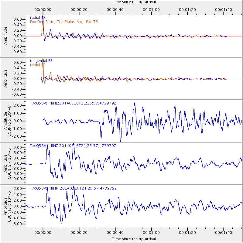
Signal To Noise
| Channel | StoN | STA | LTA |
| TA:Q58A: :BHZ:20140316T21:25:57.473979Z | 21.91315 | 4.857684E-6 | 2.2167895E-7 |
| TA:Q58A: :BHN:20140316T21:25:57.473979Z | 14.901538 | 2.5510465E-6 | 1.711935E-7 |
| TA:Q58A: :BHE:20140316T21:25:57.473979Z | 5.2154694 | 8.934526E-7 | 1.7130819E-7 |
| Arrivals |
| Ps | 4.2 SECOND |
| PpPs | 13 SECOND |
| PsPs/PpSs | 18 SECOND |


