You are here: Home > Network List > TA - USArray Transportable Network (new EarthScope stations) Stations List
> Station Q59A Harwood, MD, USA > Earthquake Result Viewer
Q59A Harwood, MD, USA - Earthquake Result Viewer
| Earthquake location: |
Near Coast Of Northern Chile |
| Earthquake latitude/longitude: |
-19.9/-70.6 |
| Earthquake time(UTC): |
2014/03/16 (075) 21:16:30 GMT |
| Earthquake Depth: |
20 km |
| Earthquake Magnitude: |
6.7 MWW, 6.7 MWC, 7.0 MI |
| Earthquake Catalog/Contributor: |
NEIC PDE/NEIC COMCAT |
|
| Network: |
TA USArray Transportable Network (new EarthScope stations) |
| Station: |
Q59A Harwood, MD, USA |
| Lat/Lon: |
38.86 N/76.65 W |
| Elevation: |
34 m |
|
| Distance: |
58.8 deg |
| Az: |
354.498 deg |
| Baz: |
173.364 deg |
| Ray Param: |
0.062617674 |
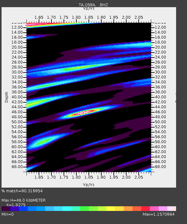
| Estimated Moho Depth: |
46.0 km |
| Estimated Crust Vp/Vs: |
1.83 |
| Assumed Crust Vp: |
6.419 km/s |
| Estimated Crust Vs: |
3.513 km/s |
| Estimated Crust Poisson's Ratio: |
0.29 |
|
| Radial Match: |
90.319954 % |
| Radial Bump: |
400 |
| Transverse Match: |
82.45241 % |
| Transverse Bump: |
400 |
| SOD ConfigId: |
626651 |
| Insert Time: |
2014-04-21 07:42:52.579 +0000 |
| GWidth: |
2.5 |
| Max Bumps: |
400 |
| Tol: |
0.001 |
|
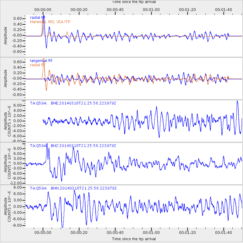
Signal To Noise
| Channel | StoN | STA | LTA |
| TA:Q59A: :BHZ:20140316T21:25:56.223979Z | 15.069048 | 5.104864E-6 | 3.3876486E-7 |
| TA:Q59A: :BHN:20140316T21:25:56.223979Z | 7.452249 | 3.1327254E-6 | 4.2037314E-7 |
| TA:Q59A: :BHE:20140316T21:25:56.223979Z | 1.1449188 | 8.236414E-7 | 7.193885E-7 |
| Arrivals |
| Ps | 6.2 SECOND |
| PpPs | 19 SECOND |
| PsPs/PpSs | 26 SECOND |


