You are here: Home > Network List > TA - USArray Transportable Network (new EarthScope stations) Stations List
> Station R58A Rapidan, VA, USA > Earthquake Result Viewer
R58A Rapidan, VA, USA - Earthquake Result Viewer
| Earthquake location: |
Near Coast Of Northern Chile |
| Earthquake latitude/longitude: |
-19.9/-70.6 |
| Earthquake time(UTC): |
2014/03/16 (075) 21:16:30 GMT |
| Earthquake Depth: |
20 km |
| Earthquake Magnitude: |
6.7 MWW, 6.7 MWC, 7.0 MI |
| Earthquake Catalog/Contributor: |
NEIC PDE/NEIC COMCAT |
|
| Network: |
TA USArray Transportable Network (new EarthScope stations) |
| Station: |
R58A Rapidan, VA, USA |
| Lat/Lon: |
38.30 N/78.00 W |
| Elevation: |
184 m |
|
| Distance: |
58.3 deg |
| Az: |
353.184 deg |
| Baz: |
171.841 deg |
| Ray Param: |
0.062893875 |
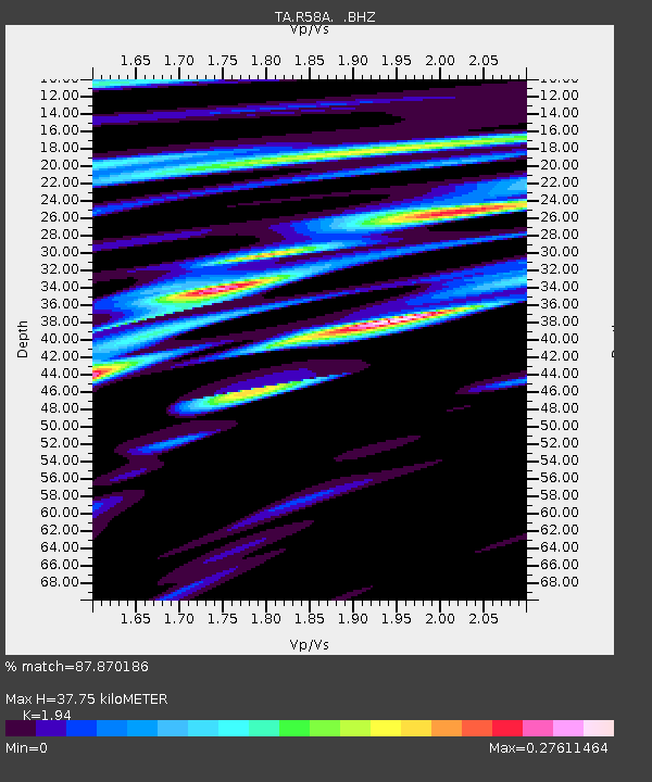
| Estimated Moho Depth: |
37.75 km |
| Estimated Crust Vp/Vs: |
1.94 |
| Assumed Crust Vp: |
6.159 km/s |
| Estimated Crust Vs: |
3.175 km/s |
| Estimated Crust Poisson's Ratio: |
0.32 |
|
| Radial Match: |
87.870186 % |
| Radial Bump: |
400 |
| Transverse Match: |
54.8358 % |
| Transverse Bump: |
400 |
| SOD ConfigId: |
626651 |
| Insert Time: |
2014-04-21 07:43:25.953 +0000 |
| GWidth: |
2.5 |
| Max Bumps: |
400 |
| Tol: |
0.001 |
|

Signal To Noise
| Channel | StoN | STA | LTA |
| TA:R58A: :BHZ:20140316T21:25:53.298992Z | 20.164501 | 5.734058E-6 | 2.8436398E-7 |
| TA:R58A: :BHN:20140316T21:25:53.298992Z | 4.044731 | 2.683637E-6 | 6.634896E-7 |
| TA:R58A: :BHE:20140316T21:25:53.298992Z | 1.8260003 | 1.7258994E-6 | 9.451802E-7 |
| Arrivals |
| Ps | 6.0 SECOND |
| PpPs | 17 SECOND |
| PsPs/PpSs | 23 SECOND |


