You are here: Home > Network List > TA - USArray Transportable Network (new EarthScope stations) Stations List
> Station S58A Poland Farm, Powhatan, VA, USA > Earthquake Result Viewer
S58A Poland Farm, Powhatan, VA, USA - Earthquake Result Viewer
| Earthquake location: |
Near Coast Of Northern Chile |
| Earthquake latitude/longitude: |
-19.9/-70.6 |
| Earthquake time(UTC): |
2014/03/16 (075) 21:16:30 GMT |
| Earthquake Depth: |
20 km |
| Earthquake Magnitude: |
6.7 MWW, 6.7 MWC, 7.0 MI |
| Earthquake Catalog/Contributor: |
NEIC PDE/NEIC COMCAT |
|
| Network: |
TA USArray Transportable Network (new EarthScope stations) |
| Station: |
S58A Poland Farm, Powhatan, VA, USA |
| Lat/Lon: |
37.61 N/78.05 W |
| Elevation: |
96 m |
|
| Distance: |
57.7 deg |
| Az: |
353.024 deg |
| Baz: |
171.727 deg |
| Ray Param: |
0.063330375 |
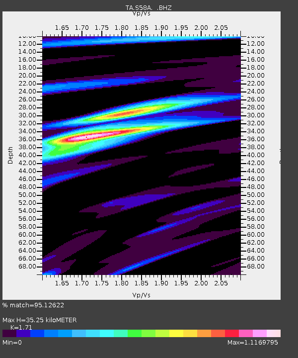
| Estimated Moho Depth: |
35.25 km |
| Estimated Crust Vp/Vs: |
1.71 |
| Assumed Crust Vp: |
6.419 km/s |
| Estimated Crust Vs: |
3.754 km/s |
| Estimated Crust Poisson's Ratio: |
0.24 |
|
| Radial Match: |
95.12622 % |
| Radial Bump: |
395 |
| Transverse Match: |
68.62006 % |
| Transverse Bump: |
400 |
| SOD ConfigId: |
626651 |
| Insert Time: |
2014-04-21 07:44:06.102 +0000 |
| GWidth: |
2.5 |
| Max Bumps: |
400 |
| Tol: |
0.001 |
|

Signal To Noise
| Channel | StoN | STA | LTA |
| TA:S58A: :BHZ:20140316T21:25:48.574993Z | 21.522396 | 5.258784E-6 | 2.4434007E-7 |
| TA:S58A: :BHN:20140316T21:25:48.574993Z | 10.392201 | 2.4922133E-6 | 2.3981573E-7 |
| TA:S58A: :BHE:20140316T21:25:48.574993Z | 1.0949174 | 4.5848753E-7 | 4.1874168E-7 |
| Arrivals |
| Ps | 4.1 SECOND |
| PpPs | 14 SECOND |
| PsPs/PpSs | 18 SECOND |


