You are here: Home > Network List > TA - USArray Transportable Network (new EarthScope stations) Stations List
> Station T53A Wise, VA, USA > Earthquake Result Viewer
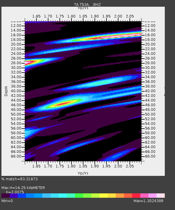
T53A Wise, VA, USA - Earthquake Result Viewer
| Earthquake location: |
Near Coast Of Northern Chile |
| Earthquake latitude/longitude: |
-19.9/-70.6 |
| Earthquake time(UTC): |
2014/03/16 (075) 21:16:30 GMT |
| Earthquake Depth: |
20 km |
| Earthquake Magnitude: |
6.7 MWW, 6.7 MWC, 7.0 MI |
| Earthquake Catalog/Contributor: |
NEIC PDE/NEIC COMCAT |
|
| Network: |
TA USArray Transportable Network (new EarthScope stations) |
| Station: |
T53A Wise, VA, USA |
| Lat/Lon: |
36.98 N/82.54 W |
| Elevation: |
818 m |
|
| Distance: |
57.7 deg |
| Az: |
348.729 deg |
| Baz: |
166.723 deg |
| Ray Param: |
0.06329807 |
| Estimated Moho Depth: |
16.25 km |
| Estimated Crust Vp/Vs: |
2.01 |
| Assumed Crust Vp: |
6.476 km/s |
| Estimated Crust Vs: |
3.226 km/s |
| Estimated Crust Poisson's Ratio: |
0.33 |
|
| Radial Match: |
93.31673 % |
| Radial Bump: |
400 |
| Transverse Match: |
76.172745 % |
| Transverse Bump: |
400 |
| SOD ConfigId: |
626651 |
| Insert Time: |
2014-04-21 07:44:36.353 +0000 |
| GWidth: |
2.5 |
| Max Bumps: |
400 |
| Tol: |
0.001 |
|

Signal To Noise
| Channel | StoN | STA | LTA |
| TA:T53A: :BHZ:20140316T21:25:48.925029Z | 19.32698 | 4.4334924E-6 | 2.2939395E-7 |
| TA:T53A: :BHN:20140316T21:25:48.925029Z | 10.464713 | 2.2275592E-6 | 2.1286384E-7 |
| TA:T53A: :BHE:20140316T21:25:48.925029Z | 2.5095427 | 4.4168303E-7 | 1.7600141E-7 |
| Arrivals |
| Ps | 2.6 SECOND |
| PpPs | 7.2 SECOND |
| PsPs/PpSs | 9.9 SECOND |


