You are here: Home > Network List > TA - USArray Transportable Network (new EarthScope stations) Stations List
> Station TPFO Pinon Flats, CA, USA > Earthquake Result Viewer
TPFO Pinon Flats, CA, USA - Earthquake Result Viewer
| Earthquake location: |
Near Coast Of Northern Chile |
| Earthquake latitude/longitude: |
-19.9/-70.6 |
| Earthquake time(UTC): |
2014/03/16 (075) 21:16:30 GMT |
| Earthquake Depth: |
20 km |
| Earthquake Magnitude: |
6.7 MWW, 6.7 MWC, 7.0 MI |
| Earthquake Catalog/Contributor: |
NEIC PDE/NEIC COMCAT |
|
| Network: |
TA USArray Transportable Network (new EarthScope stations) |
| Station: |
TPFO Pinon Flats, CA, USA |
| Lat/Lon: |
33.61 N/116.45 W |
| Elevation: |
1275 m |
|
| Distance: |
68.9 deg |
| Az: |
320.078 deg |
| Baz: |
133.657 deg |
| Ray Param: |
0.056003235 |
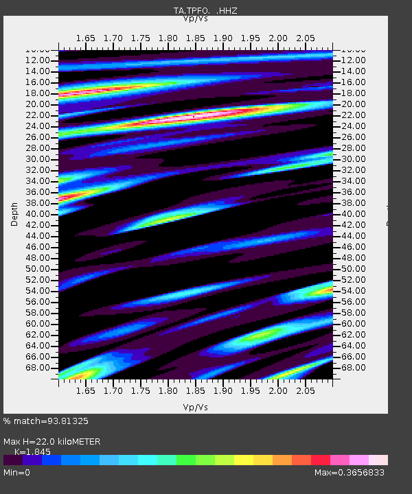
| Estimated Moho Depth: |
22.0 km |
| Estimated Crust Vp/Vs: |
1.85 |
| Assumed Crust Vp: |
6.264 km/s |
| Estimated Crust Vs: |
3.395 km/s |
| Estimated Crust Poisson's Ratio: |
0.29 |
|
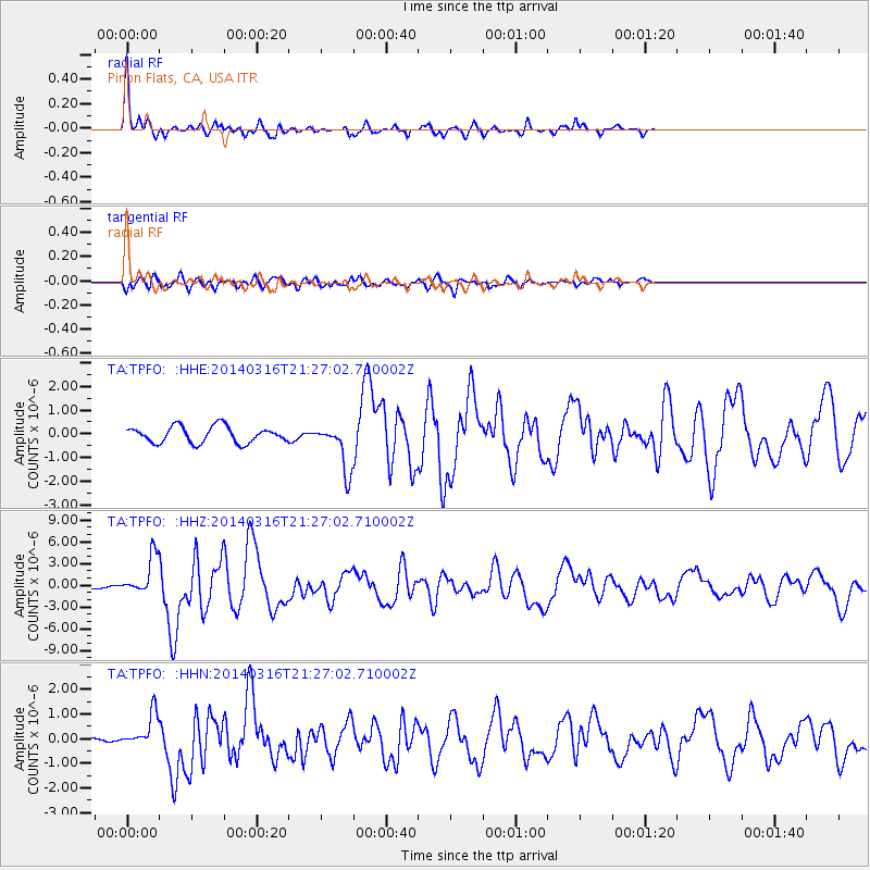
| Radial Match: |
93.81325 % |
| Radial Bump: |
311 |
| Transverse Match: |
78.2669 % |
| Transverse Bump: |
400 |
| SOD ConfigId: |
626651 |
| Insert Time: |
2014-04-21 07:44:59.370 +0000 |
| GWidth: |
2.5 |
| Max Bumps: |
400 |
| Tol: |
0.001 |
|
Signal To Noise
| Channel | StoN | STA | LTA |
| TA:TPFO: :HHZ:20140316T21:27:02.710002Z | 11.65223 | 2.679081E-6 | 2.2992002E-7 |
| TA:TPFO: :HHN:20140316T21:27:02.710002Z | 7.698142 | 6.8640054E-7 | 8.9164445E-8 |
| TA:TPFO: :HHE:20140316T21:27:02.710002Z | 2.9247222 | 9.978781E-7 | 3.4118733E-7 |
| Arrivals |
| Ps | 3.1 SECOND |
| PpPs | 9.7 SECOND |
| PsPs/PpSs | 13 SECOND |


