You are here: Home > Network List > TA - USArray Transportable Network (new EarthScope stations) Stations List
> Station Y59A Loris, SC, USA > Earthquake Result Viewer
Y59A Loris, SC, USA - Earthquake Result Viewer
| Earthquake location: |
Near Coast Of Northern Chile |
| Earthquake latitude/longitude: |
-19.9/-70.6 |
| Earthquake time(UTC): |
2014/03/16 (075) 21:16:30 GMT |
| Earthquake Depth: |
20 km |
| Earthquake Magnitude: |
6.7 MWW, 6.7 MWC, 7.0 MI |
| Earthquake Catalog/Contributor: |
NEIC PDE/NEIC COMCAT |
|
| Network: |
TA USArray Transportable Network (new EarthScope stations) |
| Station: |
Y59A Loris, SC, USA |
| Lat/Lon: |
33.99 N/78.87 W |
| Elevation: |
2.0 m |
|
| Distance: |
54.2 deg |
| Az: |
351.55 deg |
| Baz: |
170.421 deg |
| Ray Param: |
0.0655819 |
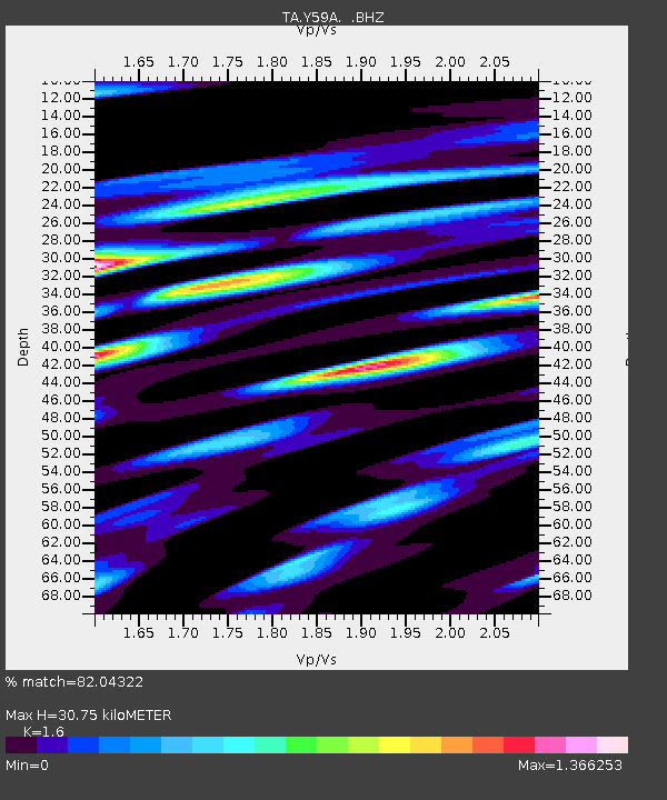
| Estimated Moho Depth: |
30.75 km |
| Estimated Crust Vp/Vs: |
1.60 |
| Assumed Crust Vp: |
6.24 km/s |
| Estimated Crust Vs: |
3.9 km/s |
| Estimated Crust Poisson's Ratio: |
0.18 |
|
| Radial Match: |
82.04322 % |
| Radial Bump: |
369 |
| Transverse Match: |
66.68617 % |
| Transverse Bump: |
377 |
| SOD ConfigId: |
626651 |
| Insert Time: |
2014-04-21 07:46:54.846 +0000 |
| GWidth: |
2.5 |
| Max Bumps: |
400 |
| Tol: |
0.001 |
|

Signal To Noise
| Channel | StoN | STA | LTA |
| TA:Y59A: :BHZ:20140316T21:25:23.800029Z | 4.915192 | 5.33572E-6 | 1.0855567E-6 |
| TA:Y59A: :BHN:20140316T21:25:23.800029Z | 1.5466979 | 4.2110373E-6 | 2.7225983E-6 |
| TA:Y59A: :BHE:20140316T21:25:23.800029Z | 1.6837415 | 3.759135E-6 | 2.2326083E-6 |
| Arrivals |
| Ps | 3.1 SECOND |
| PpPs | 12 SECOND |
| PsPs/PpSs | 15 SECOND |


