You are here: Home > Network List > TA - USArray Transportable Network (new EarthScope stations) Stations List
> Station Y60A Bolivia, NC, USA > Earthquake Result Viewer
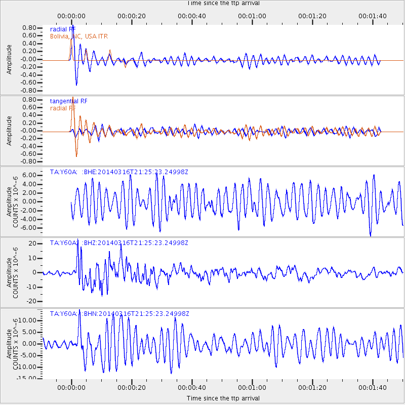
Y60A Bolivia, NC, USA - Earthquake Result Viewer
*The percent match for this event was below the threshold and hence no stack was calculated.
| Earthquake location: |
Near Coast Of Northern Chile |
| Earthquake latitude/longitude: |
-19.9/-70.6 |
| Earthquake time(UTC): |
2014/03/16 (075) 21:16:30 GMT |
| Earthquake Depth: |
20 km |
| Earthquake Magnitude: |
6.7 MWW, 6.7 MWC, 7.0 MI |
| Earthquake Catalog/Contributor: |
NEIC PDE/NEIC COMCAT |
|
| Network: |
TA USArray Transportable Network (new EarthScope stations) |
| Station: |
Y60A Bolivia, NC, USA |
| Lat/Lon: |
34.00 N/78.22 W |
| Elevation: |
7.0 m |
|
| Distance: |
54.1 deg |
| Az: |
352.218 deg |
| Baz: |
171.178 deg |
| Ray Param: |
$rayparam |
*The percent match for this event was below the threshold and hence was not used in the summary stack. |
|
| Radial Match: |
70.522835 % |
| Radial Bump: |
400 |
| Transverse Match: |
61.633343 % |
| Transverse Bump: |
400 |
| SOD ConfigId: |
626651 |
| Insert Time: |
2014-04-21 07:46:58.254 +0000 |
| GWidth: |
2.5 |
| Max Bumps: |
400 |
| Tol: |
0.001 |
|
Signal To Noise
| Channel | StoN | STA | LTA |
| TA:Y60A: :BHZ:20140316T21:25:23.24998Z | 11.496547 | 8.570643E-6 | 7.454972E-7 |
| TA:Y60A: :BHN:20140316T21:25:23.24998Z | 1.3451427 | 5.8345468E-6 | 4.337493E-6 |
| TA:Y60A: :BHE:20140316T21:25:23.24998Z | 1.0877349 | 3.1927066E-6 | 2.935188E-6 |
| Arrivals |
| Ps | |
| PpPs | |
| PsPs/PpSs | |


