You are here: Home > Network List > TA - USArray Transportable Network (new EarthScope stations) Stations List
> Station Z57A Bowman, SC, USA > Earthquake Result Viewer
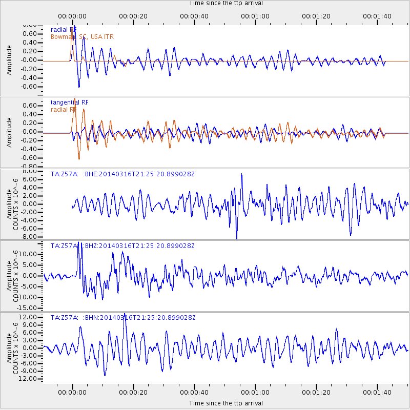
Z57A Bowman, SC, USA - Earthquake Result Viewer

| Earthquake location: |
Near Coast Of Northern Chile |
| Earthquake latitude/longitude: |
-19.9/-70.6 |
| Earthquake time(UTC): |
2014/03/16 (075) 21:16:30 GMT |
| Earthquake Depth: |
20 km |
| Earthquake Magnitude: |
6.7 MWW, 6.7 MWC, 7.0 MI |
| Earthquake Catalog/Contributor: |
NEIC PDE/NEIC COMCAT |
|
| Network: |
TA USArray Transportable Network (new EarthScope stations) |
| Station: |
Z57A Bowman, SC, USA |
| Lat/Lon: |
33.30 N/80.70 W |
| Elevation: |
81 m |
|
| Distance: |
53.8 deg |
| Az: |
349.537 deg |
| Baz: |
168.228 deg |
| Ray Param: |
0.06583882 |
| Estimated Moho Depth: |
11.0 km |
| Estimated Crust Vp/Vs: |
1.62 |
| Assumed Crust Vp: |
6.565 km/s |
| Estimated Crust Vs: |
4.04 km/s |
| Estimated Crust Poisson's Ratio: |
0.20 |
|
| Radial Match: |
92.201126 % |
| Radial Bump: |
400 |
| Transverse Match: |
67.676605 % |
| Transverse Bump: |
400 |
| SOD ConfigId: |
626651 |
| Insert Time: |
2014-04-21 07:47:07.240 +0000 |
| GWidth: |
2.5 |
| Max Bumps: |
400 |
| Tol: |
0.001 |
|
Signal To Noise
| Channel | StoN | STA | LTA |
| TA:Z57A: :BHZ:20140316T21:25:20.899028Z | 10.006661 | 6.4456267E-6 | 6.441336E-7 |
| TA:Z57A: :BHN:20140316T21:25:20.899028Z | 3.6845505 | 3.9641436E-6 | 1.0758826E-6 |
| TA:Z57A: :BHE:20140316T21:25:20.899028Z | 0.6649225 | 1.1255479E-6 | 1.6927506E-6 |
| Arrivals |
| Ps | 1.1 SECOND |
| PpPs | 4.1 SECOND |
| PsPs/PpSs | 5.2 SECOND |


