You are here: Home > Network List > GT - Global Telemetered Seismograph Network (USAF/USGS) Stations List
> Station PLCA Paso Flores, Argentina > Earthquake Result Viewer
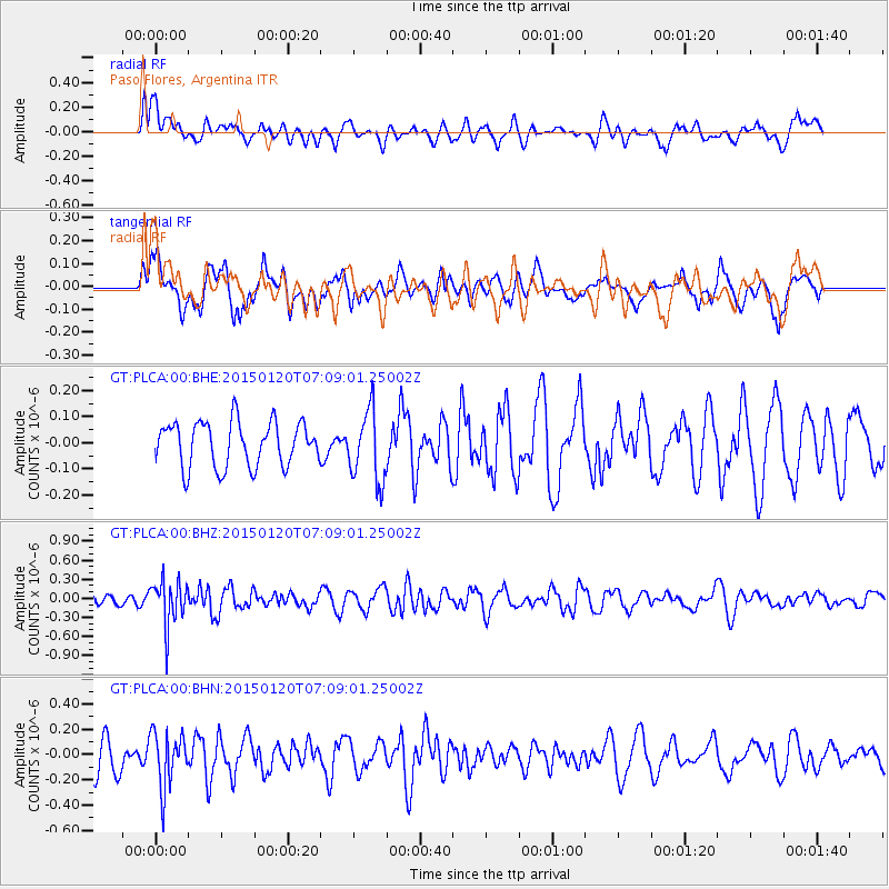
PLCA Paso Flores, Argentina - Earthquake Result Viewer
*The percent match for this event was below the threshold and hence no stack was calculated.
| Earthquake location: |
Mexico-Guatemala Border Region |
| Earthquake latitude/longitude: |
15.0/-91.3 |
| Earthquake time(UTC): |
2015/01/20 (020) 06:59:52 GMT |
| Earthquake Depth: |
162 km |
| Earthquake Magnitude: |
5.6 MB |
| Earthquake Catalog/Contributor: |
NEIC PDE/NEIC COMCAT |
|
| Network: |
GT Global Telemetered Seismograph Network (USAF/USGS) |
| Station: |
PLCA Paso Flores, Argentina |
| Lat/Lon: |
40.73 S/70.55 W |
| Elevation: |
1050 m |
|
| Distance: |
58.7 deg |
| Az: |
161.607 deg |
| Baz: |
336.346 deg |
| Ray Param: |
$rayparam |
*The percent match for this event was below the threshold and hence was not used in the summary stack. |
|
| Radial Match: |
44.944733 % |
| Radial Bump: |
400 |
| Transverse Match: |
47.854725 % |
| Transverse Bump: |
400 |
| SOD ConfigId: |
3390531 |
| Insert Time: |
2019-04-16 03:16:40.244 +0000 |
| GWidth: |
2.5 |
| Max Bumps: |
400 |
| Tol: |
0.001 |
|
Signal To Noise
| Channel | StoN | STA | LTA |
| GT:PLCA:00:BHZ:20150120T07:09:01.25002Z | 3.298097 | 3.5566424E-7 | 1.07839234E-7 |
| GT:PLCA:00:BHN:20150120T07:09:01.25002Z | 1.5596048 | 2.171243E-7 | 1.392175E-7 |
| GT:PLCA:00:BHE:20150120T07:09:01.25002Z | 1.5247768 | 1.3054218E-7 | 8.5613955E-8 |
| Arrivals |
| Ps | |
| PpPs | |
| PsPs/PpSs | |


