You are here: Home > Network List > IW - Intermountain West Stations List
> Station MOOW Moose Ponds, Wyoming, USA > Earthquake Result Viewer
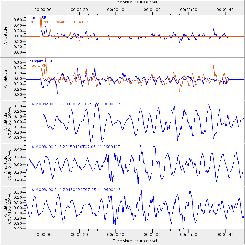
MOOW Moose Ponds, Wyoming, USA - Earthquake Result Viewer
*The percent match for this event was below the threshold and hence no stack was calculated.
| Earthquake location: |
Mexico-Guatemala Border Region |
| Earthquake latitude/longitude: |
15.0/-91.3 |
| Earthquake time(UTC): |
2015/01/20 (020) 06:59:52 GMT |
| Earthquake Depth: |
162 km |
| Earthquake Magnitude: |
5.6 MB |
| Earthquake Catalog/Contributor: |
NEIC PDE/NEIC COMCAT |
|
| Network: |
IW Intermountain West |
| Station: |
MOOW Moose Ponds, Wyoming, USA |
| Lat/Lon: |
43.75 N/110.74 W |
| Elevation: |
2128 m |
|
| Distance: |
33.1 deg |
| Az: |
333.819 deg |
| Baz: |
143.965 deg |
| Ray Param: |
$rayparam |
*The percent match for this event was below the threshold and hence was not used in the summary stack. |
|
| Radial Match: |
60.782898 % |
| Radial Bump: |
400 |
| Transverse Match: |
60.206253 % |
| Transverse Bump: |
400 |
| SOD ConfigId: |
3390531 |
| Insert Time: |
2019-04-16 03:16:50.465 +0000 |
| GWidth: |
2.5 |
| Max Bumps: |
400 |
| Tol: |
0.001 |
|
Signal To Noise
| Channel | StoN | STA | LTA |
| IW:MOOW:00:BHZ:20150120T07:05:41.960011Z | 1.141441 | 1.7618444E-7 | 1.5435265E-7 |
| IW:MOOW:00:BH1:20150120T07:05:41.960011Z | 1.208929 | 8.872071E-8 | 7.338786E-8 |
| IW:MOOW:00:BH2:20150120T07:05:41.960011Z | 1.7577448 | 2.1497497E-7 | 1.2230159E-7 |
| Arrivals |
| Ps | |
| PpPs | |
| PsPs/PpSs | |


