You are here: Home > Network List > UU - University of Utah Regional Network Stations List
> Station LCMT Little Creek Mountain, UT, USA > Earthquake Result Viewer
LCMT Little Creek Mountain, UT, USA - Earthquake Result Viewer
| Earthquake location: |
Near Coast Of Northern Chile |
| Earthquake latitude/longitude: |
-19.9/-70.6 |
| Earthquake time(UTC): |
2014/03/16 (075) 21:16:30 GMT |
| Earthquake Depth: |
20 km |
| Earthquake Magnitude: |
6.7 MWW, 6.7 MWC, 7.0 MI |
| Earthquake Catalog/Contributor: |
NEIC PDE/NEIC COMCAT |
|
| Network: |
UU University of Utah Regional Network |
| Station: |
LCMT Little Creek Mountain, UT, USA |
| Lat/Lon: |
37.01 N/113.24 W |
| Elevation: |
1411 m |
|
| Distance: |
69.4 deg |
| Az: |
324.631 deg |
| Baz: |
137.127 deg |
| Ray Param: |
0.05562504 |
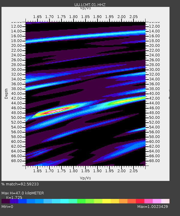
| Estimated Moho Depth: |
47.0 km |
| Estimated Crust Vp/Vs: |
1.73 |
| Assumed Crust Vp: |
6.194 km/s |
| Estimated Crust Vs: |
3.591 km/s |
| Estimated Crust Poisson's Ratio: |
0.25 |
|
| Radial Match: |
92.59233 % |
| Radial Bump: |
224 |
| Transverse Match: |
82.606155 % |
| Transverse Bump: |
379 |
| SOD ConfigId: |
626651 |
| Insert Time: |
2014-04-21 07:50:11.031 +0000 |
| GWidth: |
2.5 |
| Max Bumps: |
400 |
| Tol: |
0.001 |
|
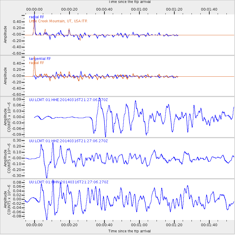
Signal To Noise
| Channel | StoN | STA | LTA |
| UU:LCMT:01:HHZ:20140316T21:27:06.270Z | 11.968597 | 9.6068575E-8 | 8.02672E-9 |
| UU:LCMT:01:HHN:20140316T21:27:06.270Z | 4.593088 | 2.9456093E-8 | 6.413134E-9 |
| UU:LCMT:01:HHE:20140316T21:27:06.270Z | 8.787802 | 3.4186996E-8 | 3.8902788E-9 |
| Arrivals |
| Ps | 5.7 SECOND |
| PpPs | 20 SECOND |
| PsPs/PpSs | 26 SECOND |


