You are here: Home > Network List > UU - University of Utah Regional Network Stations List
> Station MPU Maple Canyon, UT, USA > Earthquake Result Viewer
MPU Maple Canyon, UT, USA - Earthquake Result Viewer
| Earthquake location: |
Near Coast Of Northern Chile |
| Earthquake latitude/longitude: |
-19.9/-70.6 |
| Earthquake time(UTC): |
2014/03/16 (075) 21:16:30 GMT |
| Earthquake Depth: |
20 km |
| Earthquake Magnitude: |
6.7 MWW, 6.7 MWC, 7.0 MI |
| Earthquake Catalog/Contributor: |
NEIC PDE/NEIC COMCAT |
|
| Network: |
UU University of Utah Regional Network |
| Station: |
MPU Maple Canyon, UT, USA |
| Lat/Lon: |
40.02 N/111.63 W |
| Elevation: |
1909 m |
|
| Distance: |
70.8 deg |
| Az: |
327.759 deg |
| Baz: |
139.189 deg |
| Ray Param: |
0.054701257 |
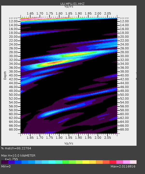
| Estimated Moho Depth: |
10.0 km |
| Estimated Crust Vp/Vs: |
1.75 |
| Assumed Crust Vp: |
6.155 km/s |
| Estimated Crust Vs: |
3.507 km/s |
| Estimated Crust Poisson's Ratio: |
0.26 |
|
| Radial Match: |
88.22784 % |
| Radial Bump: |
400 |
| Transverse Match: |
91.208855 % |
| Transverse Bump: |
400 |
| SOD ConfigId: |
626651 |
| Insert Time: |
2014-04-21 07:50:14.197 +0000 |
| GWidth: |
2.5 |
| Max Bumps: |
400 |
| Tol: |
0.001 |
|

Signal To Noise
| Channel | StoN | STA | LTA |
| UU:MPU:01:HHZ:20140316T21:27:14.774028Z | 8.3908615 | 7.872767E-8 | 9.38255E-9 |
| UU:MPU:01:HHN:20140316T21:27:14.774028Z | 3.745587 | 3.0164983E-8 | 8.053473E-9 |
| UU:MPU:01:HHE:20140316T21:27:14.774028Z | 3.2383137 | 2.476352E-8 | 7.647042E-9 |
| Arrivals |
| Ps | 1.3 SECOND |
| PpPs | 4.3 SECOND |
| PsPs/PpSs | 5.6 SECOND |


