You are here: Home > Network List > G - GEOSCOPE Stations List
> Station TAM Tamanrasset, Algeria > Earthquake Result Viewer
TAM Tamanrasset, Algeria - Earthquake Result Viewer
| Earthquake location: |
Near Coast Of Northern Chile |
| Earthquake latitude/longitude: |
-20.0/-70.9 |
| Earthquake time(UTC): |
2014/03/17 (076) 05:11:34 GMT |
| Earthquake Depth: |
17 km |
| Earthquake Magnitude: |
6.2 MWW, 6.2 MWB, 6.5 MWC |
| Earthquake Catalog/Contributor: |
NEIC PDE/NEIC COMCAT |
|
| Network: |
G GEOSCOPE |
| Station: |
TAM Tamanrasset, Algeria |
| Lat/Lon: |
22.79 N/5.53 E |
| Elevation: |
1377 m |
|
| Distance: |
85.8 deg |
| Az: |
64.077 deg |
| Baz: |
246.419 deg |
| Ray Param: |
0.044486236 |
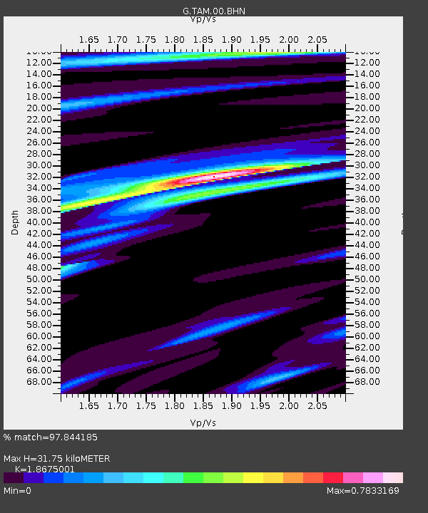
| Estimated Moho Depth: |
31.75 km |
| Estimated Crust Vp/Vs: |
1.87 |
| Assumed Crust Vp: |
6.61 km/s |
| Estimated Crust Vs: |
3.539 km/s |
| Estimated Crust Poisson's Ratio: |
0.30 |
|
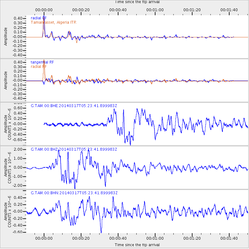
| Radial Match: |
97.844185 % |
| Radial Bump: |
289 |
| Transverse Match: |
79.65991 % |
| Transverse Bump: |
400 |
| SOD ConfigId: |
626651 |
| Insert Time: |
2014-04-21 08:01:08.103 +0000 |
| GWidth: |
2.5 |
| Max Bumps: |
400 |
| Tol: |
0.001 |
|
Signal To Noise
| Channel | StoN | STA | LTA |
| G:TAM:00:BHZ:20140317T05:23:41.899983Z | 3.2421103 | 1.8512613E-7 | 5.7100504E-8 |
| G:TAM:00:BHN:20140317T05:23:41.899983Z | 0.8975905 | 4.777163E-8 | 5.3222074E-8 |
| G:TAM:00:BHE:20140317T05:23:41.899983Z | 2.337981 | 7.3180985E-8 | 3.130093E-8 |
| Arrivals |
| Ps | 4.3 SECOND |
| PpPs | 13 SECOND |
| PsPs/PpSs | 18 SECOND |


