You are here: Home > Network List > TA - USArray Transportable Network (new EarthScope stations) Stations List
> Station G65A Princeton, ME, USA > Earthquake Result Viewer
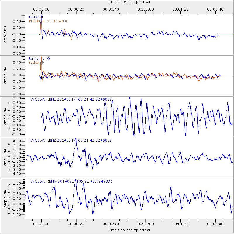
G65A Princeton, ME, USA - Earthquake Result Viewer
*The percent match for this event was below the threshold and hence no stack was calculated.
| Earthquake location: |
Near Coast Of Northern Chile |
| Earthquake latitude/longitude: |
-20.0/-70.9 |
| Earthquake time(UTC): |
2014/03/17 (076) 05:11:34 GMT |
| Earthquake Depth: |
17 km |
| Earthquake Magnitude: |
6.2 MWW, 6.2 MWB, 6.5 MWC |
| Earthquake Catalog/Contributor: |
NEIC PDE/NEIC COMCAT |
|
| Network: |
TA USArray Transportable Network (new EarthScope stations) |
| Station: |
G65A Princeton, ME, USA |
| Lat/Lon: |
45.20 N/67.56 W |
| Elevation: |
78 m |
|
| Distance: |
65.0 deg |
| Az: |
2.583 deg |
| Baz: |
183.437 deg |
| Ray Param: |
$rayparam |
*The percent match for this event was below the threshold and hence was not used in the summary stack. |
|
| Radial Match: |
56.235104 % |
| Radial Bump: |
400 |
| Transverse Match: |
50.07216 % |
| Transverse Bump: |
400 |
| SOD ConfigId: |
626651 |
| Insert Time: |
2014-04-21 08:11:51.588 +0000 |
| GWidth: |
2.5 |
| Max Bumps: |
400 |
| Tol: |
0.001 |
|
Signal To Noise
| Channel | StoN | STA | LTA |
| TA:G65A: :BHZ:20140317T05:21:42.524983Z | 0.67447704 | 3.2654538E-7 | 4.84146E-7 |
| TA:G65A: :BHN:20140317T05:21:42.524983Z | 1.0088327 | 5.22959E-7 | 5.1838026E-7 |
| TA:G65A: :BHE:20140317T05:21:42.524983Z | 1.1048371 | 2.4557687E-7 | 2.2227427E-7 |
| Arrivals |
| Ps | |
| PpPs | |
| PsPs/PpSs | |


