You are here: Home > Network List > US - United States National Seismic Network Stations List
> Station AMTX Amarillo, Texas, USA > Earthquake Result Viewer
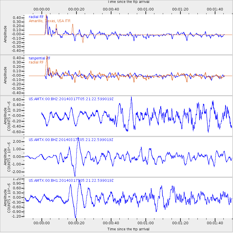
AMTX Amarillo, Texas, USA - Earthquake Result Viewer
*The percent match for this event was below the threshold and hence no stack was calculated.
| Earthquake location: |
Near Coast Of Northern Chile |
| Earthquake latitude/longitude: |
-20.0/-70.9 |
| Earthquake time(UTC): |
2014/03/17 (076) 05:11:34 GMT |
| Earthquake Depth: |
17 km |
| Earthquake Magnitude: |
6.2 MWW, 6.2 MWB, 6.5 MWC |
| Earthquake Catalog/Contributor: |
NEIC PDE/NEIC COMCAT |
|
| Network: |
US United States National Seismic Network |
| Station: |
AMTX Amarillo, Texas, USA |
| Lat/Lon: |
34.53 N/101.41 W |
| Elevation: |
1010 m |
|
| Distance: |
61.5 deg |
| Az: |
331.497 deg |
| Baz: |
147.074 deg |
| Ray Param: |
$rayparam |
*The percent match for this event was below the threshold and hence was not used in the summary stack. |
|
| Radial Match: |
78.60152 % |
| Radial Bump: |
400 |
| Transverse Match: |
54.10931 % |
| Transverse Bump: |
400 |
| SOD ConfigId: |
626651 |
| Insert Time: |
2014-04-21 08:16:57.669 +0000 |
| GWidth: |
2.5 |
| Max Bumps: |
400 |
| Tol: |
0.001 |
|
Signal To Noise
| Channel | StoN | STA | LTA |
| US:AMTX:00:BHZ:20140317T05:21:22.599019Z | 1.7785256 | 2.2335522E-7 | 1.2558448E-7 |
| US:AMTX:00:BH1:20140317T05:21:22.599019Z | 1.0435029 | 1.914835E-7 | 1.8350066E-7 |
| US:AMTX:00:BH2:20140317T05:21:22.599019Z | 0.7159955 | 1.10617265E-7 | 1.5449436E-7 |
| Arrivals |
| Ps | |
| PpPs | |
| PsPs/PpSs | |


