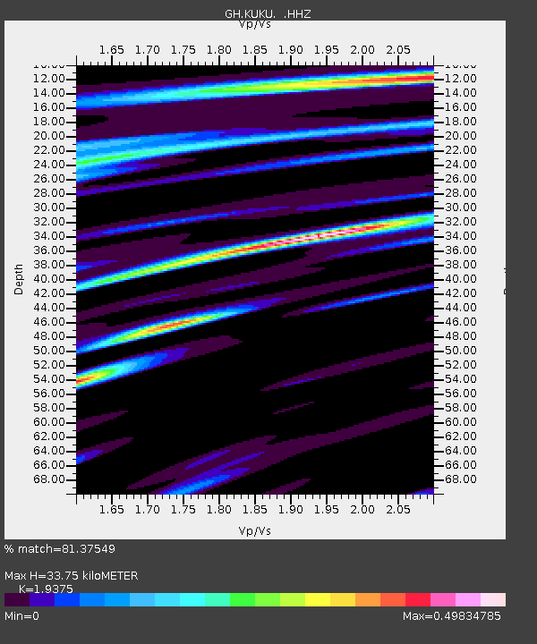
KUKU Kukurantumi, Ghana - Earthquake Result Viewer

Earthquake location: Near Coast Of Northern Chile
Earthquake latitude/longitude: -20.0/-70.8
Earthquake time(UTC): 2014/03/18 (077) 21:26:45 GMT
Earthquake Depth: 3.8 km
Earthquake Magnitude: 5.8 MWW, 5.9 MWC, 6.0 MWR, 6.0 MWB
Earthquake Catalog/Contributor: NEIC PDE/NEIC COMCAT
Network: GH Ghana Digital Seismic Network
Station: KUKU Kukurantumi, Ghana
Lat/Lon: 6.19 N/0.37 W
Elevation: 240 m
Distance: 73.9 deg
Az: 77.134 deg
Baz: 247.267 deg
Ray Param: 0.052700855
Estimated Moho Depth: 33.75 km
Estimated Crust Vp/Vs: 1.94
Assumed Crust Vp: 6.419 km/s
Estimated Crust Vs: 3.313 km/s
Estimated Crust Poisson's Ratio: 0.32
Radial Match: 81.37549 %
Radial Bump: 400
Transverse Match: 67.449104 %
Transverse Bump: 400
SOD ConfigId: 626651
Insert Time: 2014-04-21 08:32:11.943 +0000
GWidth: 2.5
Max Bumps: 400
Tol: 0.001

Signal To Noise

ChannelStoNSTALTA
GH:KUKU: :HHZ:20140318T21:37:50.240027Z5.895584.980376E-78.447644E-8
GH:KUKU: :HHN:20140318T21:37:50.240027Z1.09351428.7021064E-87.957927E-8
GH:KUKU: :HHE:20140318T21:37:50.240027Z2.70735811.9878247E-77.342304E-8
Arrivals
Ps5.1 SECOND
PpPs15 SECOND
PsPs/PpSs20 SECOND