You are here: Home > Network List > CI - Caltech Regional Seismic Network Stations List
> Station CIA Catalina Island Airport, California, USA > Earthquake Result Viewer
CIA Catalina Island Airport, California, USA - Earthquake Result Viewer
| Earthquake location: |
Hokkaido, Japan Region |
| Earthquake latitude/longitude: |
43.0/145.1 |
| Earthquake time(UTC): |
2004/11/28 (333) 18:32:14 GMT |
| Earthquake Depth: |
39 km |
| Earthquake Magnitude: |
6.4 MB, 6.7 MS, 7.0 MW, 7.0 MW |
| Earthquake Catalog/Contributor: |
WHDF/NEIC |
|
| Network: |
CI Caltech Regional Seismic Network |
| Station: |
CIA Catalina Island Airport, California, USA |
| Lat/Lon: |
33.40 N/118.42 W |
| Elevation: |
428 m |
|
| Distance: |
72.3 deg |
| Az: |
60.725 deg |
| Baz: |
310.1 deg |
| Ray Param: |
0.053656932 |
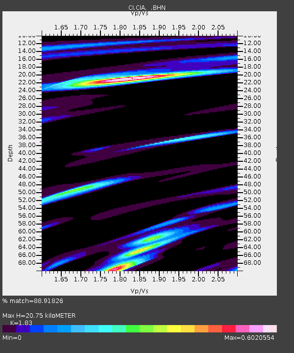
| Estimated Moho Depth: |
20.75 km |
| Estimated Crust Vp/Vs: |
1.83 |
| Assumed Crust Vp: |
6.048 km/s |
| Estimated Crust Vs: |
3.305 km/s |
| Estimated Crust Poisson's Ratio: |
0.29 |
|
| Radial Match: |
88.91826 % |
| Radial Bump: |
400 |
| Transverse Match: |
82.92698 % |
| Transverse Bump: |
400 |
| SOD ConfigId: |
2459 |
| Insert Time: |
2010-02-25 20:59:09.821 +0000 |
| GWidth: |
2.5 |
| Max Bumps: |
400 |
| Tol: |
0.001 |
|
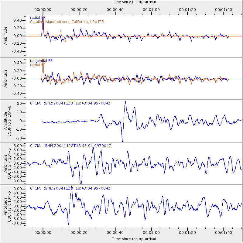
Signal To Noise
| Channel | StoN | STA | LTA |
| CI:CIA: :BHN:20041128T18:43:04.997004Z | 1.4811804 | 8.1469767E-7 | 5.5003267E-7 |
| CI:CIA: :BHE:20041128T18:43:04.997004Z | 1.6620554 | 1.3633658E-6 | 8.202891E-7 |
| CI:CIA: :BHZ:20041128T18:43:04.997004Z | 6.857912 | 4.3102764E-6 | 6.285115E-7 |
| Arrivals |
| Ps | 2.9 SECOND |
| PpPs | 9.4 SECOND |
| PsPs/PpSs | 12 SECOND |


