You are here: Home > Network List > IU - Global Seismograph Network (GSN - IRIS/USGS) Stations List
> Station PMG Port Moresby, New Guinea > Earthquake Result Viewer
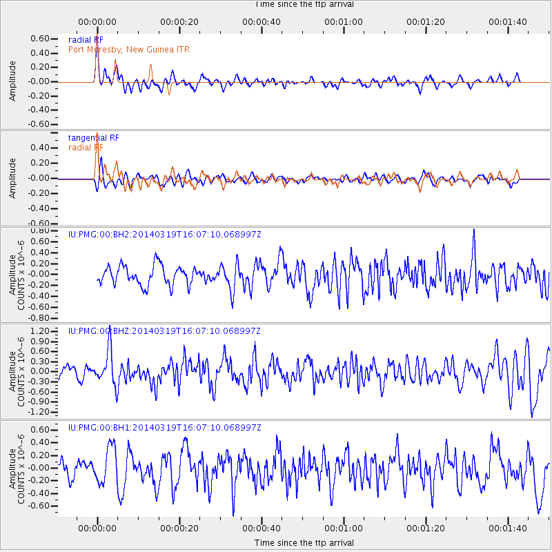
PMG Port Moresby, New Guinea - Earthquake Result Viewer
*The percent match for this event was below the threshold and hence no stack was calculated.
| Earthquake location: |
Kermadec Islands Region |
| Earthquake latitude/longitude: |
-27.9/-177.2 |
| Earthquake time(UTC): |
2014/03/19 (078) 16:00:23 GMT |
| Earthquake Depth: |
34 km |
| Earthquake Magnitude: |
5.7 MWB, 5.8 MWC, 5.8 MWW |
| Earthquake Catalog/Contributor: |
NEIC PDE/NEIC COMCAT |
|
| Network: |
IU Global Seismograph Network (GSN - IRIS/USGS) |
| Station: |
PMG Port Moresby, New Guinea |
| Lat/Lon: |
9.40 S/147.16 E |
| Elevation: |
90 m |
|
| Distance: |
38.3 deg |
| Az: |
291.788 deg |
| Baz: |
123.625 deg |
| Ray Param: |
$rayparam |
*The percent match for this event was below the threshold and hence was not used in the summary stack. |
|
| Radial Match: |
73.08749 % |
| Radial Bump: |
400 |
| Transverse Match: |
61.201874 % |
| Transverse Bump: |
400 |
| SOD ConfigId: |
626651 |
| Insert Time: |
2014-04-21 09:25:39.474 +0000 |
| GWidth: |
2.5 |
| Max Bumps: |
400 |
| Tol: |
0.001 |
|
Signal To Noise
| Channel | StoN | STA | LTA |
| IU:PMG:00:BHZ:20140319T16:07:10.068997Z | 3.136104 | 5.386436E-7 | 1.7175564E-7 |
| IU:PMG:00:BH1:20140319T16:07:10.068997Z | 1.8729678 | 2.9459693E-7 | 1.5728884E-7 |
| IU:PMG:00:BH2:20140319T16:07:10.068997Z | 1.3918172 | 2.420912E-7 | 1.7393893E-7 |
| Arrivals |
| Ps | |
| PpPs | |
| PsPs/PpSs | |


