You are here: Home > Network List > 1U - Mt. Paektu Seismic Network Stations List
> Station PDBD Paektu Bridge > Earthquake Result Viewer
PDBD Paektu Bridge - Earthquake Result Viewer
| Earthquake location: |
Vanuatu Islands |
| Earthquake latitude/longitude: |
-17.0/168.5 |
| Earthquake time(UTC): |
2015/01/23 (023) 03:47:27 GMT |
| Earthquake Depth: |
218 km |
| Earthquake Magnitude: |
6.8 MWP, 6.9 MI, 7.0 MI |
| Earthquake Catalog/Contributor: |
NEIC PDE/NEIC COMCAT |
|
| Network: |
1U Mt. Paektu Seismic Network |
| Station: |
PDBD Paektu Bridge |
| Lat/Lon: |
41.99 N/128.13 E |
| Elevation: |
2164 m |
|
| Distance: |
69.5 deg |
| Az: |
328.95 deg |
| Baz: |
138.549 deg |
| Ray Param: |
0.054951437 |
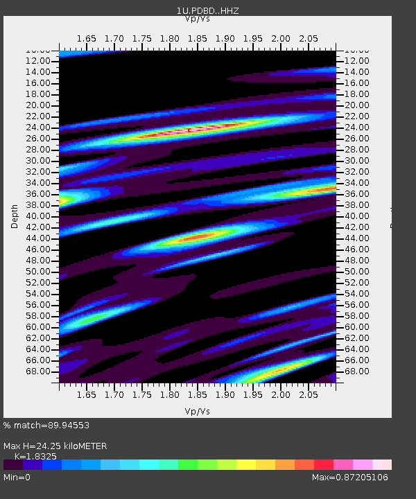
| Estimated Moho Depth: |
24.25 km |
| Estimated Crust Vp/Vs: |
1.83 |
| Assumed Crust Vp: |
6.472 km/s |
| Estimated Crust Vs: |
3.532 km/s |
| Estimated Crust Poisson's Ratio: |
0.29 |
|
| Radial Match: |
89.94553 % |
| Radial Bump: |
400 |
| Transverse Match: |
65.31117 % |
| Transverse Bump: |
400 |
| SOD ConfigId: |
3390531 |
| Insert Time: |
2019-04-16 03:39:06.423 +0000 |
| GWidth: |
2.5 |
| Max Bumps: |
400 |
| Tol: |
0.001 |
|

Signal To Noise
| Channel | StoN | STA | LTA |
| 1U:PDBD: :HHZ:20150123T03:57:41.380017Z | 4.573919 | 7.6282123E-7 | 1.6677629E-7 |
| 1U:PDBD: :HHN:20150123T03:57:41.380017Z | 0.81156224 | 2.3116466E-7 | 2.848391E-7 |
| 1U:PDBD: :HHE:20150123T03:57:41.380017Z | 1.7602049 | 3.7083325E-7 | 2.1067619E-7 |
| Arrivals |
| Ps | 3.2 SECOND |
| PpPs | 10 SECOND |
| PsPs/PpSs | 13 SECOND |


