You are here: Home > Network List > CI - Caltech Regional Seismic Network Stations List
> Station EDW2 EDW2, Mojave, CA, USA > Earthquake Result Viewer
EDW2 EDW2, Mojave, CA, USA - Earthquake Result Viewer
| Earthquake location: |
Vanuatu Islands |
| Earthquake latitude/longitude: |
-17.0/168.5 |
| Earthquake time(UTC): |
2015/01/23 (023) 03:47:27 GMT |
| Earthquake Depth: |
218 km |
| Earthquake Magnitude: |
6.8 MWP, 6.9 MI, 7.0 MI |
| Earthquake Catalog/Contributor: |
NEIC PDE/NEIC COMCAT |
|
| Network: |
CI Caltech Regional Seismic Network |
| Station: |
EDW2 EDW2, Mojave, CA, USA |
| Lat/Lon: |
34.88 N/117.99 W |
| Elevation: |
772 m |
|
| Distance: |
86.7 deg |
| Az: |
52.141 deg |
| Baz: |
246.764 deg |
| Ray Param: |
0.043373786 |
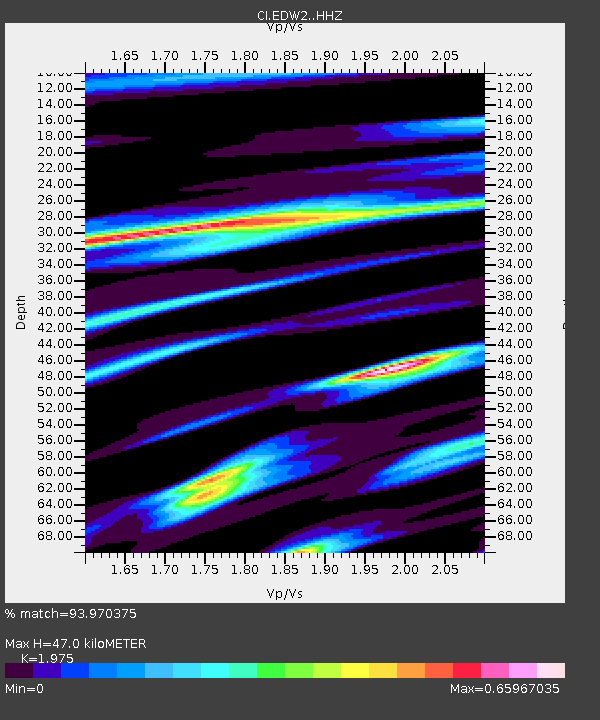
| Estimated Moho Depth: |
47.0 km |
| Estimated Crust Vp/Vs: |
1.98 |
| Assumed Crust Vp: |
6.276 km/s |
| Estimated Crust Vs: |
3.178 km/s |
| Estimated Crust Poisson's Ratio: |
0.33 |
|
| Radial Match: |
93.970375 % |
| Radial Bump: |
255 |
| Transverse Match: |
89.67672 % |
| Transverse Bump: |
269 |
| SOD ConfigId: |
3390531 |
| Insert Time: |
2019-04-16 03:40:24.092 +0000 |
| GWidth: |
2.5 |
| Max Bumps: |
400 |
| Tol: |
0.001 |
|
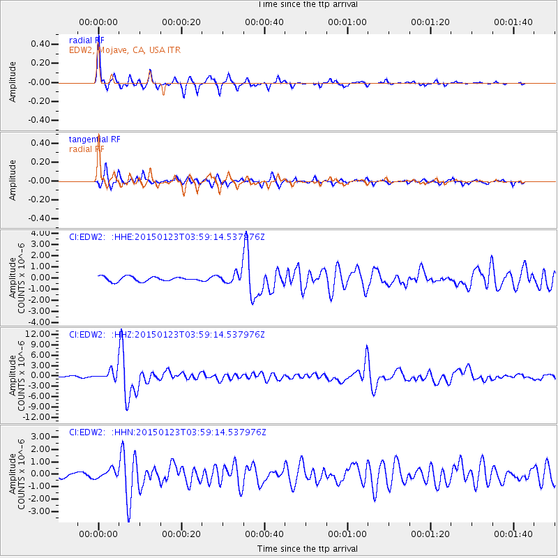
Signal To Noise
| Channel | StoN | STA | LTA |
| CI:EDW2: :HHZ:20150123T03:59:14.537976Z | 10.45533 | 1.7182102E-6 | 1.643382E-7 |
| CI:EDW2: :HHN:20150123T03:59:14.537976Z | 2.3706703 | 3.5800005E-7 | 1.5101216E-7 |
| CI:EDW2: :HHE:20150123T03:59:14.537976Z | 2.654182 | 5.4696875E-7 | 2.060781E-7 |
| Arrivals |
| Ps | 7.4 SECOND |
| PpPs | 22 SECOND |
| PsPs/PpSs | 29 SECOND |


