You are here: Home > Network List > TA - USArray Transportable Network (new EarthScope stations) Stations List
> Station HDA Harding Lake, AK, USA > Earthquake Result Viewer
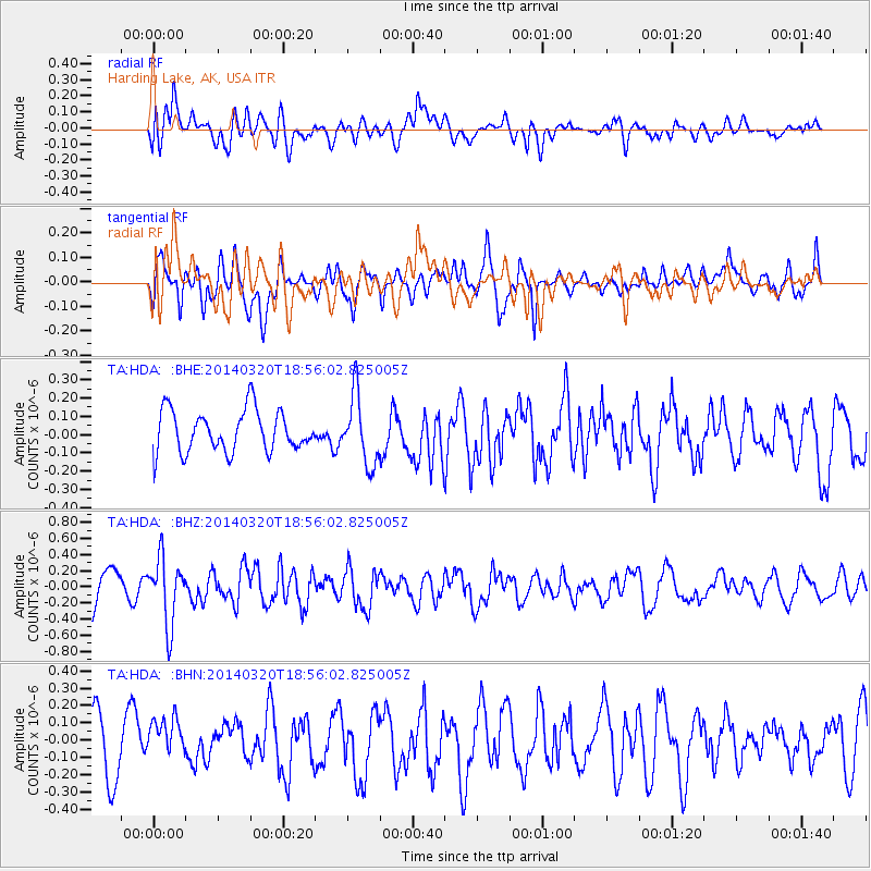
HDA Harding Lake, AK, USA - Earthquake Result Viewer
*The percent match for this event was below the threshold and hence no stack was calculated.
| Earthquake location: |
New Britain Region, P.N.G. |
| Earthquake latitude/longitude: |
-5.2/152.8 |
| Earthquake time(UTC): |
2014/03/20 (079) 18:44:14 GMT |
| Earthquake Depth: |
26 km |
| Earthquake Magnitude: |
5.6 MWW, 5.6 MWC |
| Earthquake Catalog/Contributor: |
NEIC PDE/NEIC COMCAT |
|
| Network: |
TA USArray Transportable Network (new EarthScope stations) |
| Station: |
HDA Harding Lake, AK, USA |
| Lat/Lon: |
64.41 N/146.95 W |
| Elevation: |
437 m |
|
| Distance: |
82.4 deg |
| Az: |
22.363 deg |
| Baz: |
240.743 deg |
| Ray Param: |
$rayparam |
*The percent match for this event was below the threshold and hence was not used in the summary stack. |
|
| Radial Match: |
57.87962 % |
| Radial Bump: |
400 |
| Transverse Match: |
58.33257 % |
| Transverse Bump: |
400 |
| SOD ConfigId: |
626651 |
| Insert Time: |
2014-04-21 09:48:18.089 +0000 |
| GWidth: |
2.5 |
| Max Bumps: |
400 |
| Tol: |
0.001 |
|
Signal To Noise
| Channel | StoN | STA | LTA |
| TA:HDA: :BHZ:20140320T18:56:02.825005Z | 2.1354072 | 4.0802817E-7 | 1.9107745E-7 |
| TA:HDA: :BHN:20140320T18:56:02.825005Z | 0.98638785 | 1.2469741E-7 | 1.2641823E-7 |
| TA:HDA: :BHE:20140320T18:56:02.825005Z | 1.6662306 | 1.8930497E-7 | 1.13612714E-7 |
| Arrivals |
| Ps | |
| PpPs | |
| PsPs/PpSs | |


