You are here: Home > Network List > AV - Alaska Volcano Observatory Stations List
> Station SPCR Ckakachatna River, Mount Spurr, Alaska > Earthquake Result Viewer
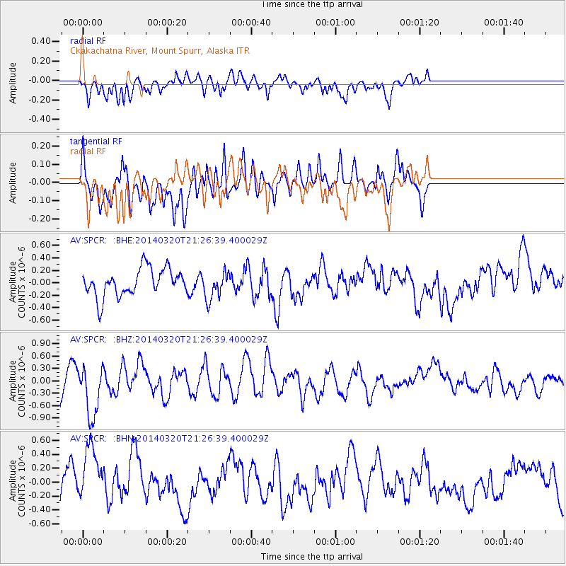
SPCR Ckakachatna River, Mount Spurr, Alaska - Earthquake Result Viewer
*The percent match for this event was below the threshold and hence no stack was calculated.
| Earthquake location: |
New Britain Region, P.N.G. |
| Earthquake latitude/longitude: |
-5.2/152.7 |
| Earthquake time(UTC): |
2014/03/20 (079) 21:15:11 GMT |
| Earthquake Depth: |
26 km |
| Earthquake Magnitude: |
5.7 MB, 5.6 MWB, 5.8 MWW, 5.8 MWC |
| Earthquake Catalog/Contributor: |
NEIC PDE/NEIC COMCAT |
|
| Network: |
AV Alaska Volcano Observatory |
| Station: |
SPCR Ckakachatna River, Mount Spurr, Alaska |
| Lat/Lon: |
61.20 N/152.21 W |
| Elevation: |
984 m |
|
| Distance: |
78.6 deg |
| Az: |
23.889 deg |
| Baz: |
236.403 deg |
| Ray Param: |
$rayparam |
*The percent match for this event was below the threshold and hence was not used in the summary stack. |
|
| Radial Match: |
57.821106 % |
| Radial Bump: |
400 |
| Transverse Match: |
59.416878 % |
| Transverse Bump: |
400 |
| SOD ConfigId: |
626651 |
| Insert Time: |
2014-04-21 09:55:02.229 +0000 |
| GWidth: |
2.5 |
| Max Bumps: |
400 |
| Tol: |
0.001 |
|
Signal To Noise
| Channel | StoN | STA | LTA |
| AV:SPCR: :BHZ:20140320T21:26:39.400029Z | 1.9708939 | 6.415603E-7 | 3.2551742E-7 |
| AV:SPCR: :BHN:20140320T21:26:39.400029Z | 1.5402555 | 4.1926614E-7 | 2.7220557E-7 |
| AV:SPCR: :BHE:20140320T21:26:39.400029Z | 1.0499084 | 2.304435E-7 | 2.1948917E-7 |
| Arrivals |
| Ps | |
| PpPs | |
| PsPs/PpSs | |


