You are here: Home > Network List > CN - Canadian National Seismograph Network Stations List
> Station INK INUVIK, NT > Earthquake Result Viewer
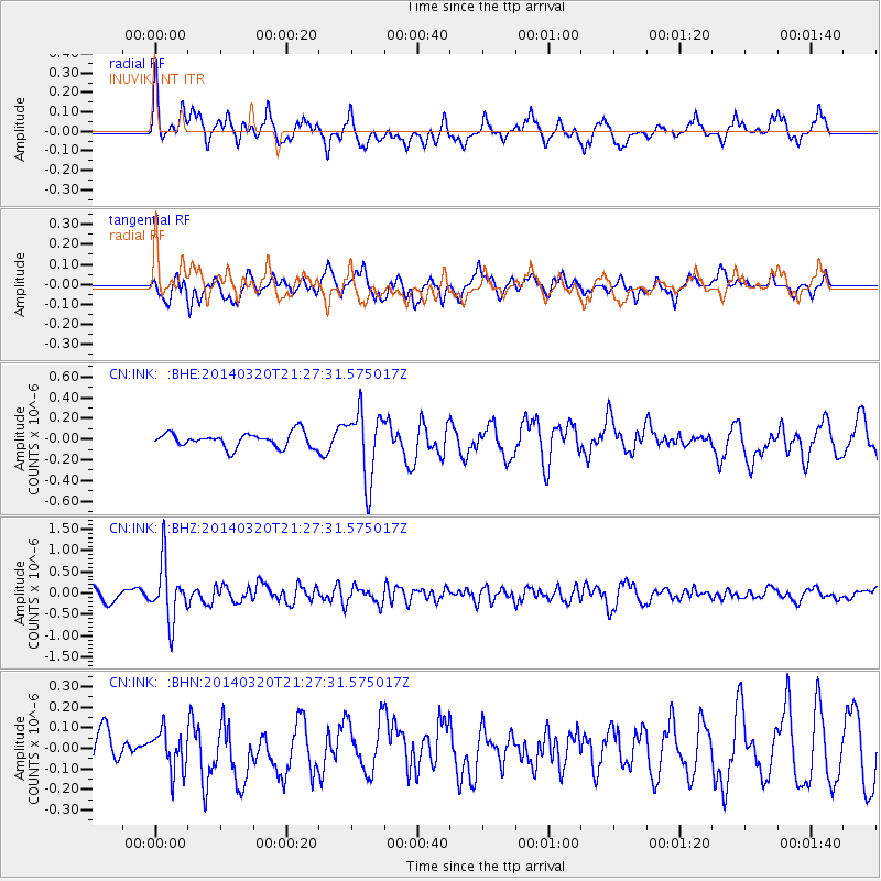
INK INUVIK, NT - Earthquake Result Viewer
*The percent match for this event was below the threshold and hence no stack was calculated.
| Earthquake location: |
New Britain Region, P.N.G. |
| Earthquake latitude/longitude: |
-5.2/152.7 |
| Earthquake time(UTC): |
2014/03/20 (079) 21:15:11 GMT |
| Earthquake Depth: |
26 km |
| Earthquake Magnitude: |
5.7 MB, 5.6 MWB, 5.8 MWW, 5.8 MWC |
| Earthquake Catalog/Contributor: |
NEIC PDE/NEIC COMCAT |
|
| Network: |
CN Canadian National Seismograph Network |
| Station: |
INK INUVIK, NT |
| Lat/Lon: |
68.31 N/133.53 W |
| Elevation: |
44 m |
|
| Distance: |
88.8 deg |
| Az: |
20.916 deg |
| Baz: |
253.014 deg |
| Ray Param: |
$rayparam |
*The percent match for this event was below the threshold and hence was not used in the summary stack. |
|
| Radial Match: |
63.24683 % |
| Radial Bump: |
400 |
| Transverse Match: |
66.46577 % |
| Transverse Bump: |
400 |
| SOD ConfigId: |
626651 |
| Insert Time: |
2014-04-21 09:57:28.777 +0000 |
| GWidth: |
2.5 |
| Max Bumps: |
400 |
| Tol: |
0.001 |
|
Signal To Noise
| Channel | StoN | STA | LTA |
| CN:INK: :BHZ:20140320T21:27:31.575017Z | 3.1923428 | 6.7090457E-7 | 2.1016056E-7 |
| CN:INK: :BHN:20140320T21:27:31.575017Z | 1.3192235 | 9.8559866E-8 | 7.4710506E-8 |
| CN:INK: :BHE:20140320T21:27:31.575017Z | 4.6780405 | 3.296664E-7 | 7.0471046E-8 |
| Arrivals |
| Ps | |
| PpPs | |
| PsPs/PpSs | |


