You are here: Home > Network List > NN - Western Great Basin/Eastern Sierra Nevada Stations List
> Station PRN Pahroc Range, Nevada. (GPS 12/04/2000) w84 > Earthquake Result Viewer
PRN Pahroc Range, Nevada. (GPS 12/04/2000) w84 - Earthquake Result Viewer
| Earthquake location: |
Vanuatu Islands |
| Earthquake latitude/longitude: |
-17.0/168.5 |
| Earthquake time(UTC): |
2015/01/23 (023) 03:47:27 GMT |
| Earthquake Depth: |
218 km |
| Earthquake Magnitude: |
6.8 MWP, 6.9 MI, 7.0 MI |
| Earthquake Catalog/Contributor: |
NEIC PDE/NEIC COMCAT |
|
| Network: |
NN Western Great Basin/Eastern Sierra Nevada |
| Station: |
PRN Pahroc Range, Nevada. (GPS 12/04/2000) w84 |
| Lat/Lon: |
37.41 N/115.05 W |
| Elevation: |
1464 m |
|
| Distance: |
89.8 deg |
| Az: |
50.718 deg |
| Baz: |
248.449 deg |
| Ray Param: |
0.041669015 |
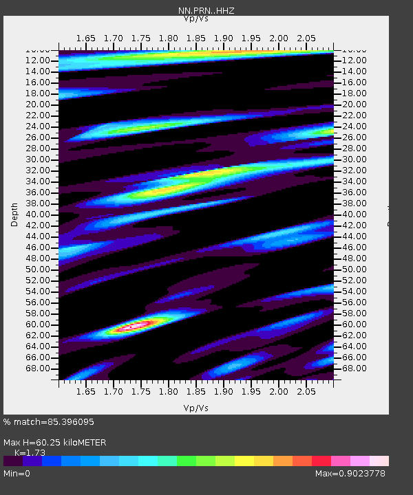
| Estimated Moho Depth: |
60.25 km |
| Estimated Crust Vp/Vs: |
1.73 |
| Assumed Crust Vp: |
6.276 km/s |
| Estimated Crust Vs: |
3.628 km/s |
| Estimated Crust Poisson's Ratio: |
0.25 |
|
| Radial Match: |
85.396095 % |
| Radial Bump: |
397 |
| Transverse Match: |
80.62014 % |
| Transverse Bump: |
400 |
| SOD ConfigId: |
3390531 |
| Insert Time: |
2019-04-16 03:42:12.634 +0000 |
| GWidth: |
2.5 |
| Max Bumps: |
400 |
| Tol: |
0.001 |
|

Signal To Noise
| Channel | StoN | STA | LTA |
| NN:PRN: :HHZ:20150123T03:59:29.394971Z | 7.1946154 | 9.3558725E-7 | 1.3003992E-7 |
| NN:PRN: :HHN:20150123T03:59:29.394971Z | 1.0348872 | 1.1547713E-7 | 1.11584264E-7 |
| NN:PRN: :HHE:20150123T03:59:29.394971Z | 2.7101696 | 2.6755933E-7 | 9.872421E-8 |
| Arrivals |
| Ps | 7.2 SECOND |
| PpPs | 26 SECOND |
| PsPs/PpSs | 33 SECOND |


