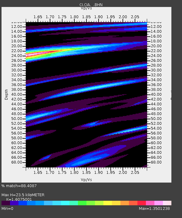
CIA Catalina Island Airport, California, USA - Earthquake Result Viewer
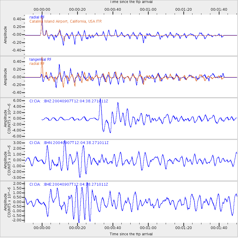
Earthquake location: Santiago Del Estero Prov., Arg.
Earthquake latitude/longitude: -28.6/-65.8
Earthquake time(UTC): 2004/09/07 (251) 11:53:06 GMT
Earthquake Depth: 22 km
Earthquake Magnitude: 6.1 MB, 6.1 MS, 6.4 MW, 6.2 MW
Earthquake Catalog/Contributor: WHDF/NEIC
Network: CI Caltech Regional Seismic Network
Station: CIA Catalina Island Airport, California, USA
Lat/Lon: 33.40 N/118.42 W
Elevation: 428 m
Distance: 79.3 deg
Az: 317.454 deg
Baz: 134.687 deg
Ray Param: 0.04906274
Estimated Moho Depth: 23.5 km
Estimated Crust Vp/Vs: 1.61
Assumed Crust Vp: 6.048 km/s
Estimated Crust Vs: 3.762 km/s
Estimated Crust Poisson's Ratio: 0.18
Radial Match: 88.4087 %
Radial Bump: 346
Transverse Match: 83.742966 %
Transverse Bump: 390
SOD ConfigId: 2459
Insert Time: 2010-02-25 20:59:16.827 +0000
GWidth: 2.5
Max Bumps: 400
Tol: 0.001

Signal To Noise

ChannelStoNSTALTA
CI:CIA: :BHN:20040907T12:04:38.271011Z3.564061.0964199E-63.076323E-7
CI:CIA: :BHE:20040907T12:04:38.271011Z2.80477437.2587693E-72.5880047E-7
CI:CIA: :BHZ:20040907T12:04:38.271011Z8.1771382.7581314E-63.3729788E-7
Arrivals
Ps2.4 SECOND
PpPs9.8 SECOND
PsPs/PpSs12 SECOND