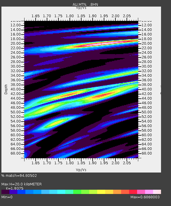
MTN Manton Dam, Northern Territory - Earthquake Result Viewer

Earthquake location: Nicobar Islands, India Region
Earthquake latitude/longitude: 7.8/94.3
Earthquake time(UTC): 2014/03/21 (080) 13:41:07 GMT
Earthquake Depth: 10 km
Earthquake Magnitude: 6.5 MWB, 6.4 MWC, 6.4 MWB, 6.4 MWW
Earthquake Catalog/Contributor: NEIC PDE/NEIC COMCAT
Network: AU Australian Seismological Centre
Station: MTN Manton Dam, Northern Territory
Lat/Lon: 12.84 S/131.13 E
Elevation: 137 m
Distance: 41.9 deg
Az: 118.987 deg
Baz: 297.283 deg
Ray Param: 0.07348913
Estimated Moho Depth: 20.0 km
Estimated Crust Vp/Vs: 1.94
Assumed Crust Vp: 6.61 km/s
Estimated Crust Vs: 3.412 km/s
Estimated Crust Poisson's Ratio: 0.32
Radial Match: 94.80502 %
Radial Bump: 237
Transverse Match: 62.309853 %
Transverse Bump: 400
SOD ConfigId: 626651
Insert Time: 2014-04-21 10:07:54.735 +0000
GWidth: 2.5
Max Bumps: 400
Tol: 0.001

Signal To Noise

ChannelStoNSTALTA
AU:MTN: :BHZ:20140321T13:48:27.218994Z4.15719464.848226E-71.16622545E-7
AU:MTN: :BHN:20140321T13:48:27.218994Z1.41946571.496816E-71.0544925E-7
AU:MTN: :BHE:20140321T13:48:27.218994Z2.38829113.079605E-71.2894596E-7
Arrivals
Ps3.0 SECOND
PpPs8.3 SECOND
PsPs/PpSs11 SECOND