You are here: Home > Network List > TA - USArray Transportable Network (new EarthScope stations) Stations List
> Station A21K Barrow, AK, USA > Earthquake Result Viewer
A21K Barrow, AK, USA - Earthquake Result Viewer

| Earthquake location: |
Vanuatu Islands |
| Earthquake latitude/longitude: |
-17.0/168.5 |
| Earthquake time(UTC): |
2015/01/23 (023) 03:47:27 GMT |
| Earthquake Depth: |
218 km |
| Earthquake Magnitude: |
6.8 MWP, 6.9 MI, 7.0 MI |
| Earthquake Catalog/Contributor: |
NEIC PDE/NEIC COMCAT |
|
| Network: |
TA USArray Transportable Network (new EarthScope stations) |
| Station: |
A21K Barrow, AK, USA |
| Lat/Lon: |
71.32 N/156.62 W |
| Elevation: |
577 m |
|
| Distance: |
91.3 deg |
| Az: |
10.612 deg |
| Baz: |
213.156 deg |
| Ray Param: |
0.04153294 |
| Estimated Moho Depth: |
31.0 km |
| Estimated Crust Vp/Vs: |
1.78 |
| Assumed Crust Vp: |
6.048 km/s |
| Estimated Crust Vs: |
3.402 km/s |
| Estimated Crust Poisson's Ratio: |
0.27 |
|
| Radial Match: |
88.136604 % |
| Radial Bump: |
400 |
| Transverse Match: |
82.26494 % |
| Transverse Bump: |
400 |
| SOD ConfigId: |
3390531 |
| Insert Time: |
2019-04-16 03:43:01.652 +0000 |
| GWidth: |
2.5 |
| Max Bumps: |
400 |
| Tol: |
0.001 |
|
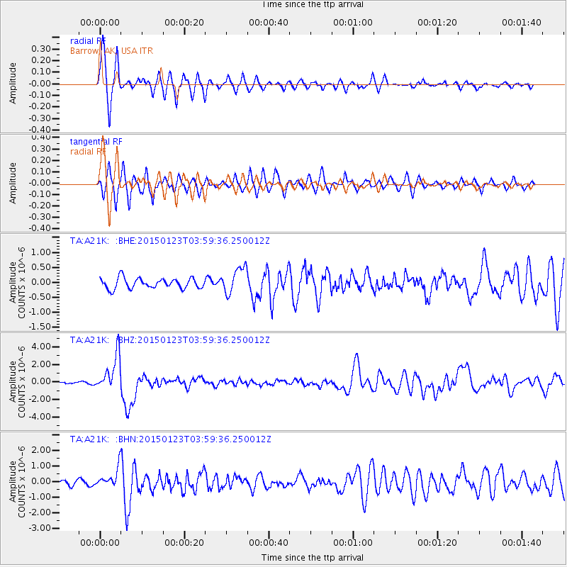
Signal To Noise
| Channel | StoN | STA | LTA |
| TA:A21K: :BHZ:20150123T03:59:36.250012Z | 19.301815 | 2.1152975E-6 | 1.0959061E-7 |
| TA:A21K: :BHN:20150123T03:59:36.250012Z | 3.4888825 | 6.4155597E-7 | 1.8388579E-7 |
| TA:A21K: :BHE:20150123T03:59:36.250012Z | 2.5615945 | 4.3946426E-7 | 1.7155887E-7 |
| Arrivals |
| Ps | 4.1 SECOND |
| PpPs | 14 SECOND |
| PsPs/PpSs | 18 SECOND |


