You are here: Home > Network List > TA - USArray Transportable Network (new EarthScope stations) Stations List
> Station C06D Leavenworth, WQ, USA > Earthquake Result Viewer
C06D Leavenworth, WQ, USA - Earthquake Result Viewer
| Earthquake location: |
Vanuatu Islands |
| Earthquake latitude/longitude: |
-17.0/168.5 |
| Earthquake time(UTC): |
2015/01/23 (023) 03:47:27 GMT |
| Earthquake Depth: |
218 km |
| Earthquake Magnitude: |
6.8 MWP, 6.9 MI, 7.0 MI |
| Earthquake Catalog/Contributor: |
NEIC PDE/NEIC COMCAT |
|
| Network: |
TA USArray Transportable Network (new EarthScope stations) |
| Station: |
C06D Leavenworth, WQ, USA |
| Lat/Lon: |
47.92 N/120.89 W |
| Elevation: |
544 m |
|
| Distance: |
90.1 deg |
| Az: |
39.369 deg |
| Baz: |
244.473 deg |
| Ray Param: |
0.041652054 |
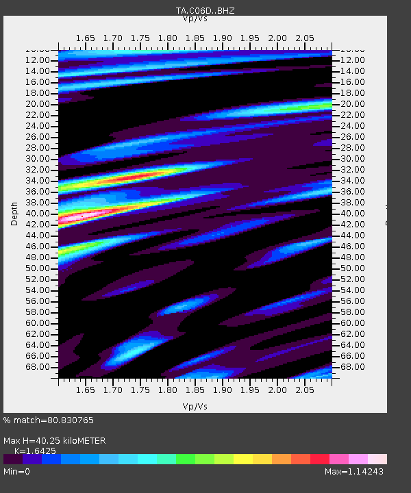
| Estimated Moho Depth: |
40.25 km |
| Estimated Crust Vp/Vs: |
1.64 |
| Assumed Crust Vp: |
6.597 km/s |
| Estimated Crust Vs: |
4.017 km/s |
| Estimated Crust Poisson's Ratio: |
0.21 |
|
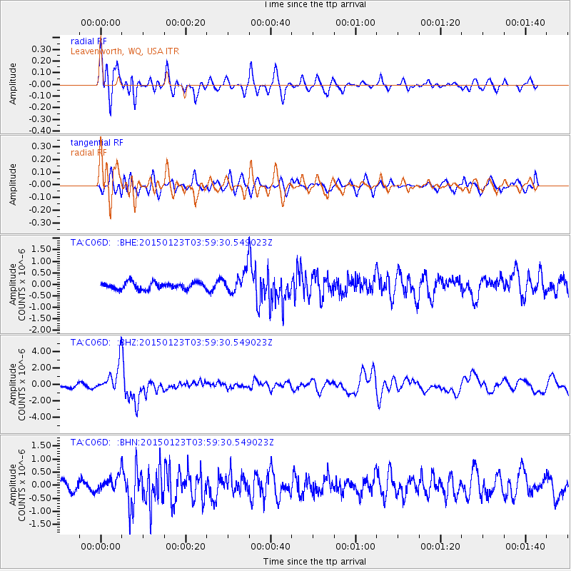
| Radial Match: |
80.830765 % |
| Radial Bump: |
400 |
| Transverse Match: |
64.11307 % |
| Transverse Bump: |
400 |
| SOD ConfigId: |
3390531 |
| Insert Time: |
2019-04-16 03:43:05.052 +0000 |
| GWidth: |
2.5 |
| Max Bumps: |
400 |
| Tol: |
0.001 |
|
Signal To Noise
| Channel | StoN | STA | LTA |
| TA:C06D: :BHZ:20150123T03:59:30.549023Z | 10.816489 | 1.9129347E-6 | 1.7685356E-7 |
| TA:C06D: :BHN:20150123T03:59:30.549023Z | 1.3504416 | 3.1718702E-7 | 2.3487654E-7 |
| TA:C06D: :BHE:20150123T03:59:30.549023Z | 3.4157443 | 5.100872E-7 | 1.4933413E-7 |
| Arrivals |
| Ps | 4.0 SECOND |
| PpPs | 16 SECOND |
| PsPs/PpSs | 20 SECOND |


