You are here: Home > Network List > TA - USArray Transportable Network (new EarthScope stations) Stations List
> Station J04D Umpqua National Forest, Toketee, OR, USA > Earthquake Result Viewer
J04D Umpqua National Forest, Toketee, OR, USA - Earthquake Result Viewer
| Earthquake location: |
Vanuatu Islands |
| Earthquake latitude/longitude: |
-17.0/168.5 |
| Earthquake time(UTC): |
2015/01/23 (023) 03:47:27 GMT |
| Earthquake Depth: |
218 km |
| Earthquake Magnitude: |
6.8 MWP, 6.9 MI, 7.0 MI |
| Earthquake Catalog/Contributor: |
NEIC PDE/NEIC COMCAT |
|
| Network: |
TA USArray Transportable Network (new EarthScope stations) |
| Station: |
J04D Umpqua National Forest, Toketee, OR, USA |
| Lat/Lon: |
43.24 N/122.11 W |
| Elevation: |
1948 m |
|
| Distance: |
87.2 deg |
| Az: |
43.209 deg |
| Baz: |
243.697 deg |
| Ray Param: |
0.042952456 |
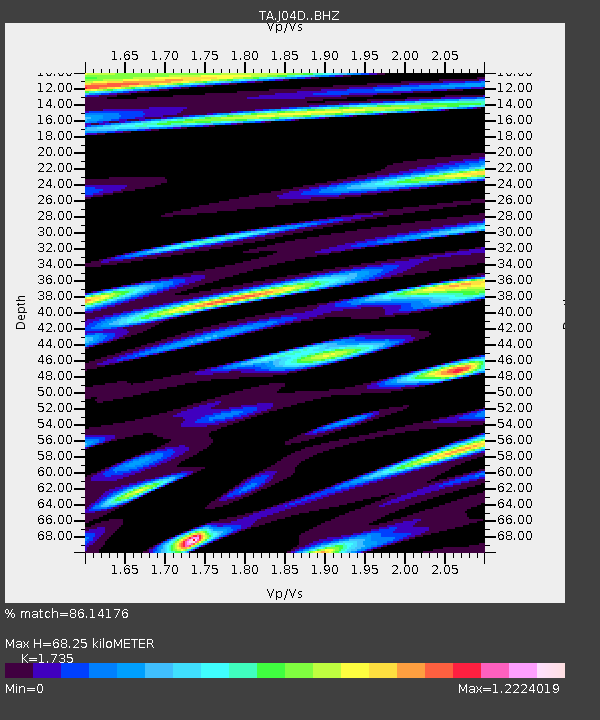
| Estimated Moho Depth: |
68.25 km |
| Estimated Crust Vp/Vs: |
1.74 |
| Assumed Crust Vp: |
6.522 km/s |
| Estimated Crust Vs: |
3.759 km/s |
| Estimated Crust Poisson's Ratio: |
0.25 |
|
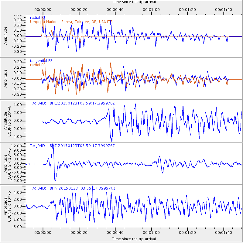
| Radial Match: |
86.14176 % |
| Radial Bump: |
400 |
| Transverse Match: |
77.807976 % |
| Transverse Bump: |
400 |
| SOD ConfigId: |
3390531 |
| Insert Time: |
2019-04-16 03:43:15.748 +0000 |
| GWidth: |
2.5 |
| Max Bumps: |
400 |
| Tol: |
0.001 |
|
Signal To Noise
| Channel | StoN | STA | LTA |
| TA:J04D: :BHZ:20150123T03:59:17.399976Z | 4.745019 | 1.8803441E-6 | 3.9627747E-7 |
| TA:J04D: :BHN:20150123T03:59:17.399976Z | 1.1196026 | 5.899102E-7 | 5.268925E-7 |
| TA:J04D: :BHE:20150123T03:59:17.399976Z | 1.7097214 | 5.797386E-7 | 3.3908367E-7 |
| Arrivals |
| Ps | 7.9 SECOND |
| PpPs | 28 SECOND |
| PsPs/PpSs | 36 SECOND |


