You are here: Home > Network List > TA - USArray Transportable Network (new EarthScope stations) Stations List
> Station TPFO Pinon Flats, CA, USA > Earthquake Result Viewer
TPFO Pinon Flats, CA, USA - Earthquake Result Viewer

| Earthquake location: |
Vanuatu Islands |
| Earthquake latitude/longitude: |
-17.0/168.5 |
| Earthquake time(UTC): |
2015/01/23 (023) 03:47:27 GMT |
| Earthquake Depth: |
218 km |
| Earthquake Magnitude: |
6.8 MWP, 6.9 MI, 7.0 MI |
| Earthquake Catalog/Contributor: |
NEIC PDE/NEIC COMCAT |
|
| Network: |
TA USArray Transportable Network (new EarthScope stations) |
| Station: |
TPFO Pinon Flats, CA, USA |
| Lat/Lon: |
33.61 N/116.45 W |
| Elevation: |
1275 m |
|
| Distance: |
87.3 deg |
| Az: |
53.809 deg |
| Baz: |
247.714 deg |
| Ray Param: |
0.042880055 |
| Estimated Moho Depth: |
69.75 km |
| Estimated Crust Vp/Vs: |
1.73 |
| Assumed Crust Vp: |
6.264 km/s |
| Estimated Crust Vs: |
3.615 km/s |
| Estimated Crust Poisson's Ratio: |
0.25 |
|
| Radial Match: |
90.96793 % |
| Radial Bump: |
182 |
| Transverse Match: |
76.860695 % |
| Transverse Bump: |
332 |
| SOD ConfigId: |
3390531 |
| Insert Time: |
2019-04-16 03:43:27.727 +0000 |
| GWidth: |
2.5 |
| Max Bumps: |
400 |
| Tol: |
0.001 |
|
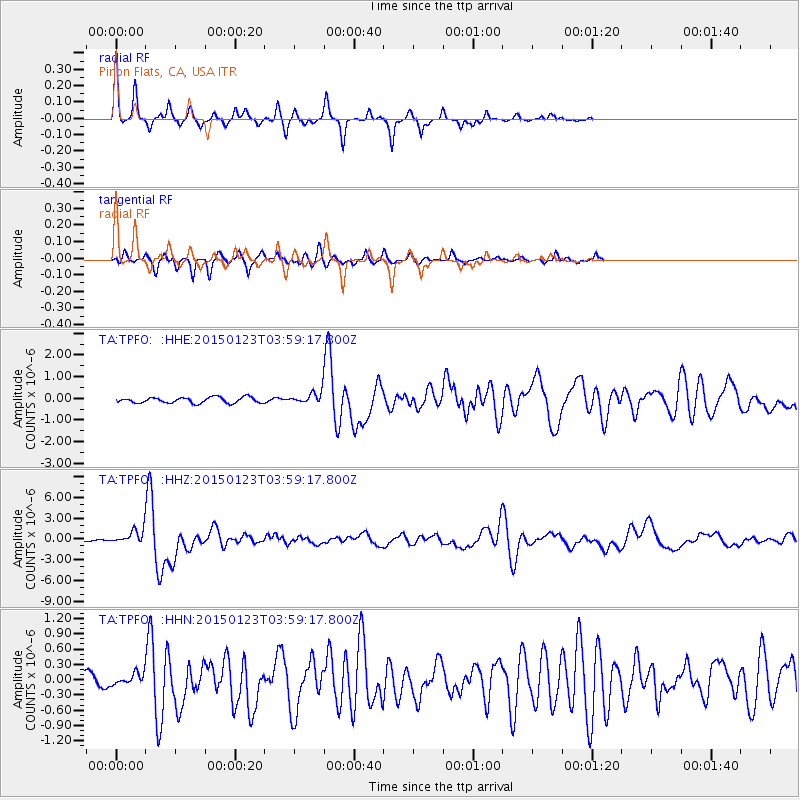
Signal To Noise
| Channel | StoN | STA | LTA |
| TA:TPFO: :HHZ:20150123T03:59:17.800Z | 7.184085 | 1.2991978E-6 | 1.808439E-7 |
| TA:TPFO: :HHN:20150123T03:59:17.800Z | 0.8875741 | 1.3306877E-7 | 1.4992412E-7 |
| TA:TPFO: :HHE:20150123T03:59:17.800Z | 2.8531563 | 3.7392604E-7 | 1.3105698E-7 |
| Arrivals |
| Ps | 8.3 SECOND |
| PpPs | 30 SECOND |
| PsPs/PpSs | 38 SECOND |


