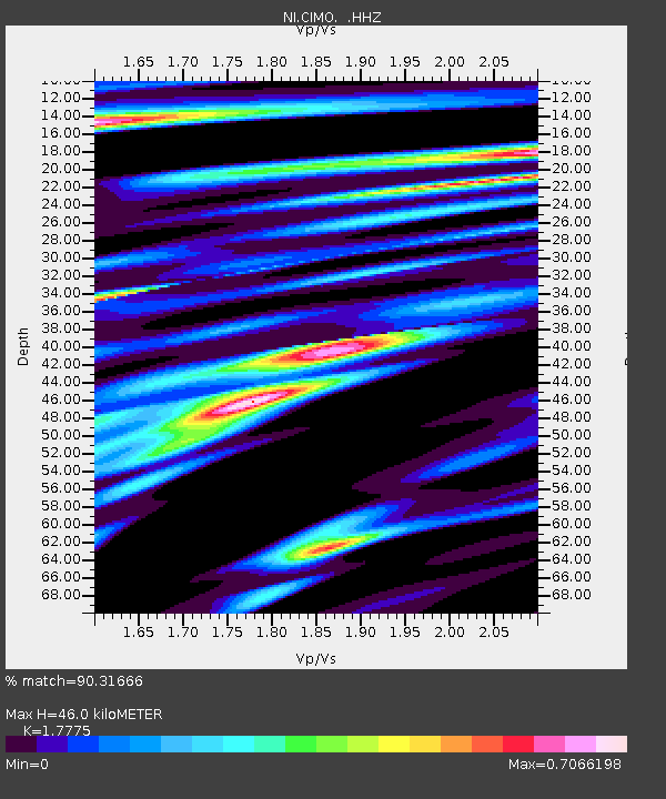
CIMO Cimolais - Earthquake Result Viewer

Earthquake location: Nicobar Islands, India Region
Earthquake latitude/longitude: 7.8/94.3
Earthquake time(UTC): 2014/03/21 (080) 13:41:07 GMT
Earthquake Depth: 10 km
Earthquake Magnitude: 6.5 MWB, 6.4 MWC, 6.4 MWB, 6.4 MWW
Earthquake Catalog/Contributor: NEIC PDE/NEIC COMCAT
Network: NI North-East Italy Broadband Network
Station: CIMO Cimolais
Lat/Lon: 46.31 N/12.44 E
Elevation: 728 m
Distance: 78.8 deg
Az: 315.615 deg
Baz: 90.456 deg
Ray Param: 0.049379162
Estimated Moho Depth: 46.0 km
Estimated Crust Vp/Vs: 1.78
Assumed Crust Vp: 6.35 km/s
Estimated Crust Vs: 3.572 km/s
Estimated Crust Poisson's Ratio: 0.27
Radial Match: 90.31666 %
Radial Bump: 400
Transverse Match: 79.83831 %
Transverse Bump: 400
SOD ConfigId: 626651
Insert Time: 2014-04-21 10:14:25.885 +0000
GWidth: 2.5
Max Bumps: 400
Tol: 0.001

Signal To Noise

ChannelStoNSTALTA
NI:CIMO: :HHZ:20140321T13:52:39.122009Z6.40982441.309359E-62.0427377E-7
NI:CIMO: :HHN:20140321T13:52:39.122009Z1.41354692.5896642E-71.8320328E-7
NI:CIMO: :HHE:20140321T13:52:39.122009Z1.91207124.04141E-72.1136293E-7
Arrivals
Ps5.8 SECOND
PpPs20 SECOND
PsPs/PpSs25 SECOND