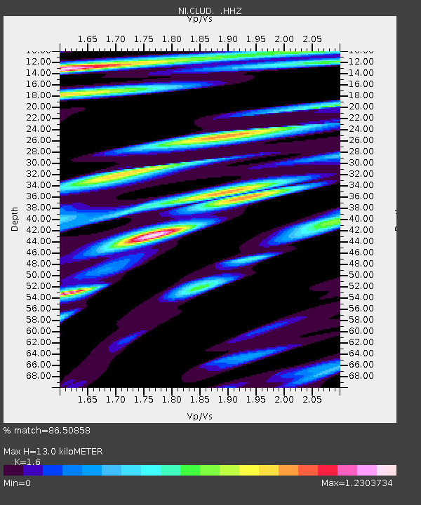
CLUD Cludinico - Earthquake Result Viewer

Earthquake location: Nicobar Islands, India Region
Earthquake latitude/longitude: 7.8/94.3
Earthquake time(UTC): 2014/03/21 (080) 13:41:07 GMT
Earthquake Depth: 10 km
Earthquake Magnitude: 6.5 MWB, 6.4 MWC, 6.4 MWB, 6.4 MWW
Earthquake Catalog/Contributor: NEIC PDE/NEIC COMCAT
Network: NI North-East Italy Broadband Network
Station: CLUD Cludinico
Lat/Lon: 46.46 N/12.88 E
Elevation: 635 m
Distance: 78.5 deg
Az: 315.767 deg
Baz: 90.801 deg
Ray Param: 0.04958281
Estimated Moho Depth: 13.0 km
Estimated Crust Vp/Vs: 1.60
Assumed Crust Vp: 6.35 km/s
Estimated Crust Vs: 3.969 km/s
Estimated Crust Poisson's Ratio: 0.18
Radial Match: 86.50858 %
Radial Bump: 400
Transverse Match: 75.61487 %
Transverse Bump: 400
SOD ConfigId: 626651
Insert Time: 2014-04-21 10:14:27.825 +0000
GWidth: 2.5
Max Bumps: 400
Tol: 0.001

Signal To Noise

ChannelStoNSTALTA
NI:CLUD: :HHZ:20140321T13:52:37.468018Z3.14307211.1389592E-63.623713E-7
NI:CLUD: :HHN:20140321T13:52:37.468018Z1.38928821.7845353E-71.2844961E-7
NI:CLUD: :HHE:20140321T13:52:37.468018Z1.64592983.0734546E-71.867306E-7
Arrivals
Ps1.3 SECOND
PpPs5.2 SECOND
PsPs/PpSs6.4 SECOND