You are here: Home > Network List > XD14 - Illuminating the architecture of the greater Mount St. Helens magmatic systems f Stations List
> Station MH11 "Mount St Helens, WA" > Earthquake Result Viewer
MH11 "Mount St Helens, WA" - Earthquake Result Viewer
| Earthquake location: |
Vanuatu Islands |
| Earthquake latitude/longitude: |
-17.0/168.5 |
| Earthquake time(UTC): |
2015/01/23 (023) 03:47:27 GMT |
| Earthquake Depth: |
218 km |
| Earthquake Magnitude: |
6.8 MWP, 6.9 MI, 7.0 MI |
| Earthquake Catalog/Contributor: |
NEIC PDE/NEIC COMCAT |
|
| Network: |
XD Illuminating the architecture of the greater Mount St. Helens magmatic systems f |
| Station: |
MH11 "Mount St Helens, WA" |
| Lat/Lon: |
46.27 N/121.58 W |
| Elevation: |
1447 m |
|
| Distance: |
88.9 deg |
| Az: |
40.655 deg |
| Baz: |
243.984 deg |
| Ray Param: |
0.04173323 |
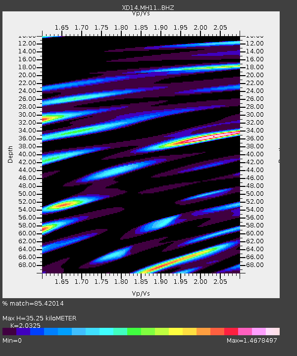
| Estimated Moho Depth: |
35.25 km |
| Estimated Crust Vp/Vs: |
2.03 |
| Assumed Crust Vp: |
6.597 km/s |
| Estimated Crust Vs: |
3.246 km/s |
| Estimated Crust Poisson's Ratio: |
0.34 |
|
| Radial Match: |
85.42014 % |
| Radial Bump: |
400 |
| Transverse Match: |
81.98847 % |
| Transverse Bump: |
400 |
| SOD ConfigId: |
3390531 |
| Insert Time: |
2019-04-16 03:44:59.327 +0000 |
| GWidth: |
2.5 |
| Max Bumps: |
400 |
| Tol: |
0.001 |
|

Signal To Noise
| Channel | StoN | STA | LTA |
| XD:MH11: :BHZ:20150123T03:59:25.274976Z | 6.123123 | 1.7325458E-6 | 2.829513E-7 |
| XD:MH11: :BHN:20150123T03:59:25.274976Z | 1.160042 | 4.4267577E-7 | 3.816032E-7 |
| XD:MH11: :BHE:20150123T03:59:25.274976Z | 1.5240616 | 7.739886E-7 | 5.0784604E-7 |
| Arrivals |
| Ps | 5.6 SECOND |
| PpPs | 16 SECOND |
| PsPs/PpSs | 22 SECOND |


