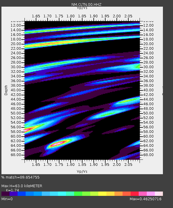
CLTN Cedars of Lebanon,TN - Earthquake Result Viewer

Earthquake location: Near Coast Of Northern Chile
Earthquake latitude/longitude: -19.8/-70.9
Earthquake time(UTC): 2014/03/22 (081) 12:59:59 GMT
Earthquake Depth: 20 km
Earthquake Magnitude: 6.2 MWW, 6.2 MWB, 6.3 MWC, 6.4 MWC
Earthquake Catalog/Contributor: NEIC PDE/NEIC COMCAT
Network: NM Cooperative New Madrid Seismic Network
Station: CLTN Cedars of Lebanon,TN
Lat/Lon: 36.09 N/86.33 W
Elevation: 208 m
Distance: 57.4 deg
Az: 345.16 deg
Baz: 162.674 deg
Ray Param: 0.06346375
Estimated Moho Depth: 63.0 km
Estimated Crust Vp/Vs: 1.74
Assumed Crust Vp: 6.444 km/s
Estimated Crust Vs: 3.703 km/s
Estimated Crust Poisson's Ratio: 0.25
Radial Match: 89.654755 %
Radial Bump: 332
Transverse Match: 65.647705 %
Transverse Bump: 400
SOD ConfigId: 626651
Insert Time: 2014-04-21 10:30:04.806 +0000
GWidth: 2.5
Max Bumps: 400
Tol: 0.001

Signal To Noise

ChannelStoNSTALTA
NM:CLTN:00:HHZ:20140322T13:09:15.475012Z9.2483499.143469E-79.886596E-8
NM:CLTN:00:HHN:20140322T13:09:15.475012Z6.61167864.4118792E-76.6728575E-8
NM:CLTN:00:HHE:20140322T13:09:15.475012Z2.41359262.401472E-79.949781E-8
Arrivals
Ps7.6 SECOND
PpPs25 SECOND
PsPs/PpSs33 SECOND