You are here: Home > Network List > TA - USArray Transportable Network (new EarthScope stations) Stations List
> Station D48A Paudash Township, ON, CAN > Earthquake Result Viewer
D48A Paudash Township, ON, CAN - Earthquake Result Viewer
| Earthquake location: |
Near Coast Of Northern Chile |
| Earthquake latitude/longitude: |
-19.8/-70.9 |
| Earthquake time(UTC): |
2014/03/22 (081) 12:59:59 GMT |
| Earthquake Depth: |
20 km |
| Earthquake Magnitude: |
6.2 MWW, 6.2 MWB, 6.3 MWC, 6.4 MWC |
| Earthquake Catalog/Contributor: |
NEIC PDE/NEIC COMCAT |
|
| Network: |
TA USArray Transportable Network (new EarthScope stations) |
| Station: |
D48A Paudash Township, ON, CAN |
| Lat/Lon: |
47.17 N/81.81 W |
| Elevation: |
434 m |
|
| Distance: |
67.3 deg |
| Az: |
351.94 deg |
| Baz: |
168.839 deg |
| Ray Param: |
0.056993973 |
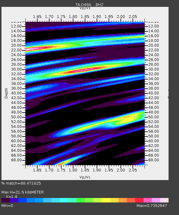
| Estimated Moho Depth: |
21.5 km |
| Estimated Crust Vp/Vs: |
1.60 |
| Assumed Crust Vp: |
6.467 km/s |
| Estimated Crust Vs: |
4.042 km/s |
| Estimated Crust Poisson's Ratio: |
0.18 |
|
| Radial Match: |
88.471825 % |
| Radial Bump: |
400 |
| Transverse Match: |
80.19098 % |
| Transverse Bump: |
400 |
| SOD ConfigId: |
626651 |
| Insert Time: |
2014-04-21 10:34:37.560 +0000 |
| GWidth: |
2.5 |
| Max Bumps: |
400 |
| Tol: |
0.001 |
|

Signal To Noise
| Channel | StoN | STA | LTA |
| TA:D48A: :BHZ:20140322T13:10:21.600012Z | 7.2461076 | 9.429774E-7 | 1.3013572E-7 |
| TA:D48A: :BHN:20140322T13:10:21.600012Z | 3.0760083 | 4.1200602E-7 | 1.3394178E-7 |
| TA:D48A: :BHE:20140322T13:10:21.600012Z | 1.0688902 | 1.3232598E-7 | 1.2379753E-7 |
| Arrivals |
| Ps | 2.1 SECOND |
| PpPs | 8.3 SECOND |
| PsPs/PpSs | 10 SECOND |


