You are here: Home > Network List > XL12 - Hangay Dome, Mongolia Stations List
> Station AT13 AT13 > Earthquake Result Viewer
AT13 AT13 - Earthquake Result Viewer
| Earthquake location: |
Vanuatu Islands |
| Earthquake latitude/longitude: |
-17.0/168.5 |
| Earthquake time(UTC): |
2015/01/23 (023) 03:47:27 GMT |
| Earthquake Depth: |
218 km |
| Earthquake Magnitude: |
6.8 MWP, 6.9 MI, 7.0 MI |
| Earthquake Catalog/Contributor: |
NEIC PDE/NEIC COMCAT |
|
| Network: |
XL Hangay Dome, Mongolia |
| Station: |
AT13 AT13 |
| Lat/Lon: |
44.99 N/96.27 E |
| Elevation: |
1091 m |
|
| Distance: |
89.9 deg |
| Az: |
317.48 deg |
| Baz: |
114.306 deg |
| Ray Param: |
0.041664686 |
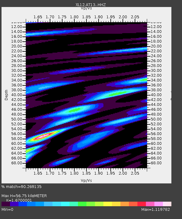
| Estimated Moho Depth: |
56.75 km |
| Estimated Crust Vp/Vs: |
1.67 |
| Assumed Crust Vp: |
6.353 km/s |
| Estimated Crust Vs: |
3.804 km/s |
| Estimated Crust Poisson's Ratio: |
0.22 |
|
| Radial Match: |
90.269135 % |
| Radial Bump: |
400 |
| Transverse Match: |
83.56578 % |
| Transverse Bump: |
400 |
| SOD ConfigId: |
3390531 |
| Insert Time: |
2019-04-16 03:45:33.751 +0000 |
| GWidth: |
2.5 |
| Max Bumps: |
400 |
| Tol: |
0.001 |
|

Signal To Noise
| Channel | StoN | STA | LTA |
| XL:AT13: :HHZ:20150123T03:59:29.859998Z | 20.334942 | 8.1097085E-7 | 3.988066E-8 |
| XL:AT13: :HHN:20150123T03:59:29.859998Z | 3.0202262 | 1.992381E-7 | 6.596794E-8 |
| XL:AT13: :HHE:20150123T03:59:29.859998Z | 5.5254335 | 3.4602334E-7 | 6.262374E-8 |
| Arrivals |
| Ps | 6.1 SECOND |
| PpPs | 23 SECOND |
| PsPs/PpSs | 29 SECOND |


