You are here: Home > Network List > TA - USArray Transportable Network (new EarthScope stations) Stations List
> Station I49A Point Hope, MI, USA > Earthquake Result Viewer
I49A Point Hope, MI, USA - Earthquake Result Viewer
| Earthquake location: |
Near Coast Of Northern Chile |
| Earthquake latitude/longitude: |
-19.8/-70.9 |
| Earthquake time(UTC): |
2014/03/22 (081) 12:59:59 GMT |
| Earthquake Depth: |
20 km |
| Earthquake Magnitude: |
6.2 MWW, 6.2 MWB, 6.3 MWC, 6.4 MWC |
| Earthquake Catalog/Contributor: |
NEIC PDE/NEIC COMCAT |
|
| Network: |
TA USArray Transportable Network (new EarthScope stations) |
| Station: |
I49A Point Hope, MI, USA |
| Lat/Lon: |
43.94 N/82.82 W |
| Elevation: |
217 m |
|
| Distance: |
64.3 deg |
| Az: |
350.447 deg |
| Baz: |
167.504 deg |
| Ray Param: |
0.05897048 |
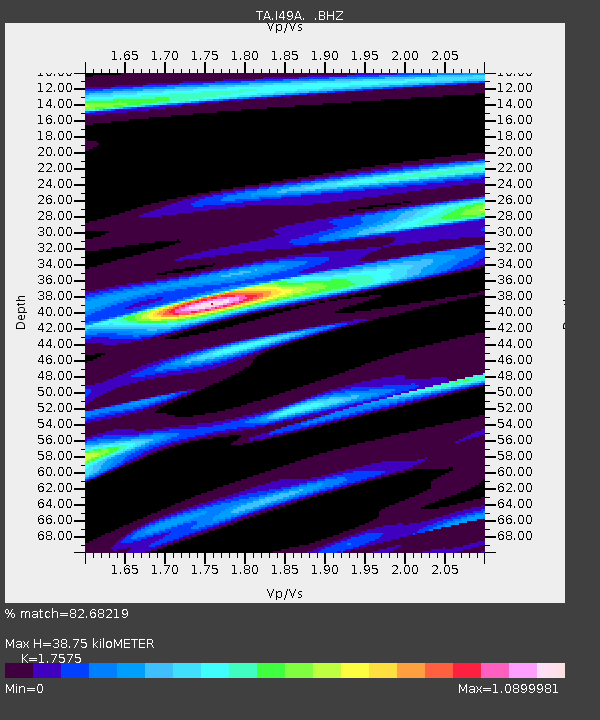
| Estimated Moho Depth: |
38.75 km |
| Estimated Crust Vp/Vs: |
1.76 |
| Assumed Crust Vp: |
6.483 km/s |
| Estimated Crust Vs: |
3.689 km/s |
| Estimated Crust Poisson's Ratio: |
0.26 |
|
| Radial Match: |
82.68219 % |
| Radial Bump: |
348 |
| Transverse Match: |
51.514862 % |
| Transverse Bump: |
400 |
| SOD ConfigId: |
626651 |
| Insert Time: |
2014-04-21 10:37:27.423 +0000 |
| GWidth: |
2.5 |
| Max Bumps: |
400 |
| Tol: |
0.001 |
|

Signal To Noise
| Channel | StoN | STA | LTA |
| TA:I49A: :BHZ:20140322T13:10:02.199988Z | 4.8320565 | 1.176915E-6 | 2.43564E-7 |
| TA:I49A: :BHN:20140322T13:10:02.199988Z | 2.070865 | 4.7643093E-7 | 2.3006375E-7 |
| TA:I49A: :BHE:20140322T13:10:02.199988Z | 1.791059 | 3.438381E-7 | 1.9197476E-7 |
| Arrivals |
| Ps | 4.7 SECOND |
| PpPs | 16 SECOND |
| PsPs/PpSs | 21 SECOND |


