You are here: Home > Network List > TA - USArray Transportable Network (new EarthScope stations) Stations List
> Station L53A Girard, PA, USA > Earthquake Result Viewer
L53A Girard, PA, USA - Earthquake Result Viewer
| Earthquake location: |
Near Coast Of Northern Chile |
| Earthquake latitude/longitude: |
-19.8/-70.9 |
| Earthquake time(UTC): |
2014/03/22 (081) 12:59:59 GMT |
| Earthquake Depth: |
20 km |
| Earthquake Magnitude: |
6.2 MWW, 6.2 MWB, 6.3 MWC, 6.4 MWC |
| Earthquake Catalog/Contributor: |
NEIC PDE/NEIC COMCAT |
|
| Network: |
TA USArray Transportable Network (new EarthScope stations) |
| Station: |
L53A Girard, PA, USA |
| Lat/Lon: |
41.95 N/80.26 W |
| Elevation: |
355 m |
|
| Distance: |
62.0 deg |
| Az: |
352.082 deg |
| Baz: |
169.984 deg |
| Ray Param: |
0.060483955 |
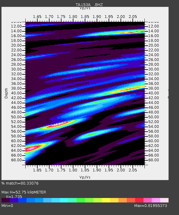
| Estimated Moho Depth: |
52.75 km |
| Estimated Crust Vp/Vs: |
1.74 |
| Assumed Crust Vp: |
6.483 km/s |
| Estimated Crust Vs: |
3.736 km/s |
| Estimated Crust Poisson's Ratio: |
0.25 |
|
| Radial Match: |
80.33076 % |
| Radial Bump: |
400 |
| Transverse Match: |
76.33696 % |
| Transverse Bump: |
400 |
| SOD ConfigId: |
626651 |
| Insert Time: |
2014-04-21 10:39:28.021 +0000 |
| GWidth: |
2.5 |
| Max Bumps: |
400 |
| Tol: |
0.001 |
|

Signal To Noise
| Channel | StoN | STA | LTA |
| TA:L53A: :BHZ:20140322T13:09:46.874976Z | 3.3297276 | 7.3884087E-7 | 2.2189228E-7 |
| TA:L53A: :BHN:20140322T13:09:46.874976Z | 2.0541904 | 4.4910368E-7 | 2.1862806E-7 |
| TA:L53A: :BHE:20140322T13:09:46.874976Z | 0.68329436 | 1.2611986E-7 | 1.8457617E-7 |
| Arrivals |
| Ps | 6.3 SECOND |
| PpPs | 21 SECOND |
| PsPs/PpSs | 28 SECOND |


