You are here: Home > Network List > TA - USArray Transportable Network (new EarthScope stations) Stations List
> Station L60A Shokan, NY, USA > Earthquake Result Viewer
L60A Shokan, NY, USA - Earthquake Result Viewer
| Earthquake location: |
Near Coast Of Northern Chile |
| Earthquake latitude/longitude: |
-19.8/-70.9 |
| Earthquake time(UTC): |
2014/03/22 (081) 12:59:59 GMT |
| Earthquake Depth: |
20 km |
| Earthquake Magnitude: |
6.2 MWW, 6.2 MWB, 6.3 MWC, 6.4 MWC |
| Earthquake Catalog/Contributor: |
NEIC PDE/NEIC COMCAT |
|
| Network: |
TA USArray Transportable Network (new EarthScope stations) |
| Station: |
L60A Shokan, NY, USA |
| Lat/Lon: |
41.99 N/74.22 W |
| Elevation: |
388 m |
|
| Distance: |
61.5 deg |
| Az: |
357.16 deg |
| Baz: |
176.412 deg |
| Ray Param: |
0.06080195 |
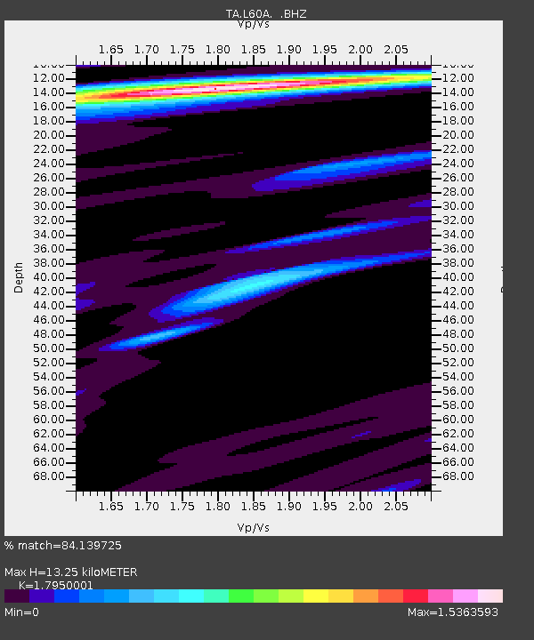
| Estimated Moho Depth: |
13.25 km |
| Estimated Crust Vp/Vs: |
1.80 |
| Assumed Crust Vp: |
6.283 km/s |
| Estimated Crust Vs: |
3.5 km/s |
| Estimated Crust Poisson's Ratio: |
0.27 |
|
| Radial Match: |
84.139725 % |
| Radial Bump: |
400 |
| Transverse Match: |
65.168884 % |
| Transverse Bump: |
400 |
| SOD ConfigId: |
626651 |
| Insert Time: |
2014-04-21 10:39:38.382 +0000 |
| GWidth: |
2.5 |
| Max Bumps: |
400 |
| Tol: |
0.001 |
|
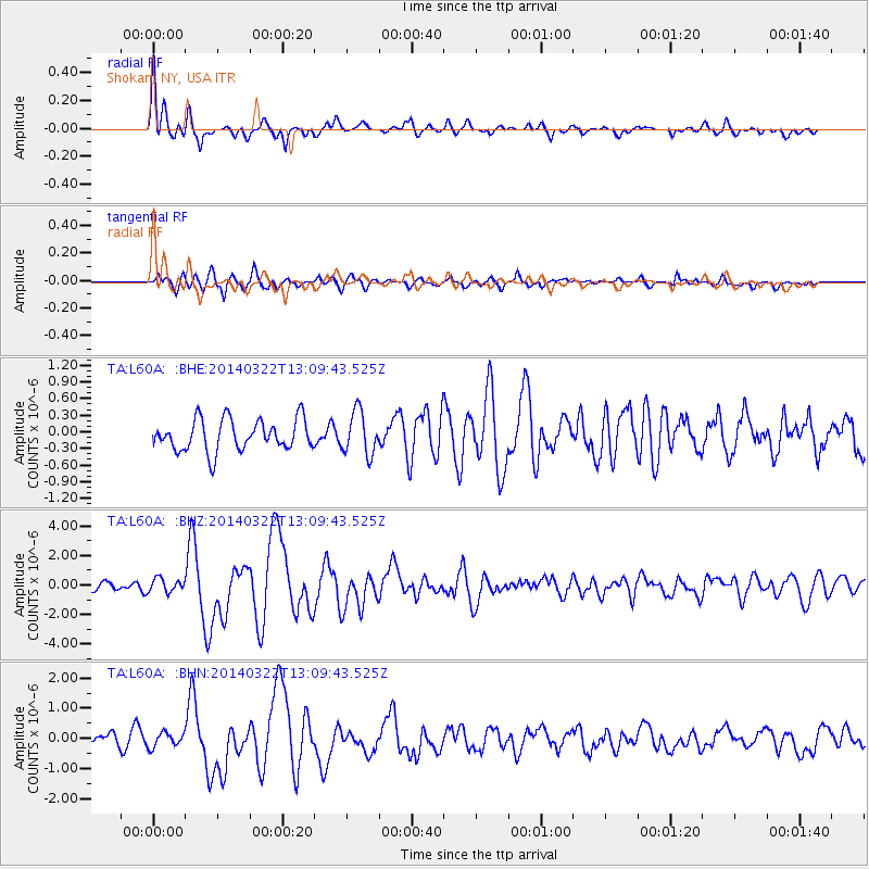
Signal To Noise
| Channel | StoN | STA | LTA |
| TA:L60A: :BHZ:20140322T13:09:43.525Z | 1.391296 | 4.5267282E-7 | 3.2536053E-7 |
| TA:L60A: :BHN:20140322T13:09:43.525Z | 0.9395877 | 2.5165608E-7 | 2.678367E-7 |
| TA:L60A: :BHE:20140322T13:09:43.525Z | 1.3649633 | 3.8346724E-7 | 2.8093595E-7 |
| Arrivals |
| Ps | 1.7 SECOND |
| PpPs | 5.6 SECOND |
| PsPs/PpSs | 7.4 SECOND |


