You are here: Home > Network List > TA - USArray Transportable Network (new EarthScope stations) Stations List
> Station MDND Maddock, ND, USA > Earthquake Result Viewer
MDND Maddock, ND, USA - Earthquake Result Viewer
| Earthquake location: |
Near Coast Of Northern Chile |
| Earthquake latitude/longitude: |
-19.8/-70.9 |
| Earthquake time(UTC): |
2014/03/22 (081) 12:59:59 GMT |
| Earthquake Depth: |
20 km |
| Earthquake Magnitude: |
6.2 MWW, 6.2 MWB, 6.3 MWC, 6.4 MWC |
| Earthquake Catalog/Contributor: |
NEIC PDE/NEIC COMCAT |
|
| Network: |
TA USArray Transportable Network (new EarthScope stations) |
| Station: |
MDND Maddock, ND, USA |
| Lat/Lon: |
47.85 N/99.60 W |
| Elevation: |
479 m |
|
| Distance: |
72.1 deg |
| Az: |
340.105 deg |
| Baz: |
151.588 deg |
| Ray Param: |
0.05388639 |
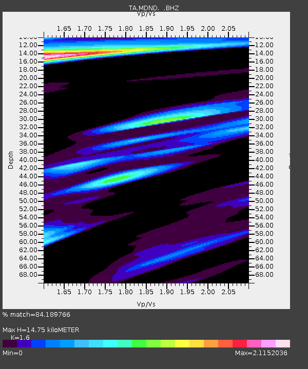
| Estimated Moho Depth: |
14.75 km |
| Estimated Crust Vp/Vs: |
1.60 |
| Assumed Crust Vp: |
6.53 km/s |
| Estimated Crust Vs: |
4.082 km/s |
| Estimated Crust Poisson's Ratio: |
0.18 |
|
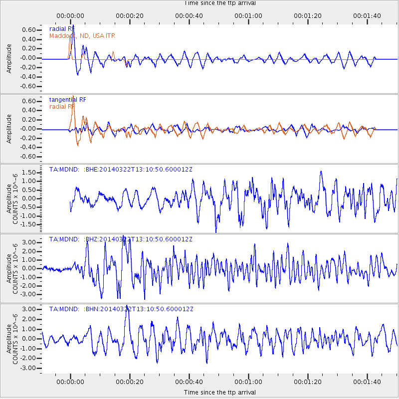
| Radial Match: |
84.189766 % |
| Radial Bump: |
400 |
| Transverse Match: |
69.76805 % |
| Transverse Bump: |
400 |
| SOD ConfigId: |
626651 |
| Insert Time: |
2014-04-21 10:40:26.152 +0000 |
| GWidth: |
2.5 |
| Max Bumps: |
400 |
| Tol: |
0.001 |
|
Signal To Noise
| Channel | StoN | STA | LTA |
| TA:MDND: :BHZ:20140322T13:10:50.600012Z | 1.9665078 | 4.078789E-7 | 2.0741281E-7 |
| TA:MDND: :BHN:20140322T13:10:50.600012Z | 0.6210478 | 2.831814E-7 | 4.5597363E-7 |
| TA:MDND: :BHE:20140322T13:10:50.600012Z | 1.0195068 | 3.4603838E-7 | 3.3941743E-7 |
| Arrivals |
| Ps | 1.4 SECOND |
| PpPs | 5.6 SECOND |
| PsPs/PpSs | 7.1 SECOND |


