You are here: Home > Network List > TA - USArray Transportable Network (new EarthScope stations) Stations List
> Station N50A Nevada, OH, USA > Earthquake Result Viewer
N50A Nevada, OH, USA - Earthquake Result Viewer
| Earthquake location: |
Near Coast Of Northern Chile |
| Earthquake latitude/longitude: |
-19.8/-70.9 |
| Earthquake time(UTC): |
2014/03/22 (081) 12:59:59 GMT |
| Earthquake Depth: |
20 km |
| Earthquake Magnitude: |
6.2 MWW, 6.2 MWB, 6.3 MWC, 6.4 MWC |
| Earthquake Catalog/Contributor: |
NEIC PDE/NEIC COMCAT |
|
| Network: |
TA USArray Transportable Network (new EarthScope stations) |
| Station: |
N50A Nevada, OH, USA |
| Lat/Lon: |
40.77 N/83.15 W |
| Elevation: |
277 m |
|
| Distance: |
61.3 deg |
| Az: |
349.392 deg |
| Baz: |
166.804 deg |
| Ray Param: |
0.060943227 |
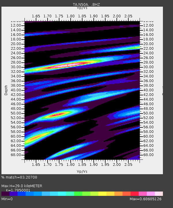
| Estimated Moho Depth: |
29.0 km |
| Estimated Crust Vp/Vs: |
1.79 |
| Assumed Crust Vp: |
6.498 km/s |
| Estimated Crust Vs: |
3.64 km/s |
| Estimated Crust Poisson's Ratio: |
0.27 |
|
| Radial Match: |
83.20708 % |
| Radial Bump: |
400 |
| Transverse Match: |
72.98934 % |
| Transverse Bump: |
400 |
| SOD ConfigId: |
626651 |
| Insert Time: |
2014-04-21 10:40:41.290 +0000 |
| GWidth: |
2.5 |
| Max Bumps: |
400 |
| Tol: |
0.001 |
|
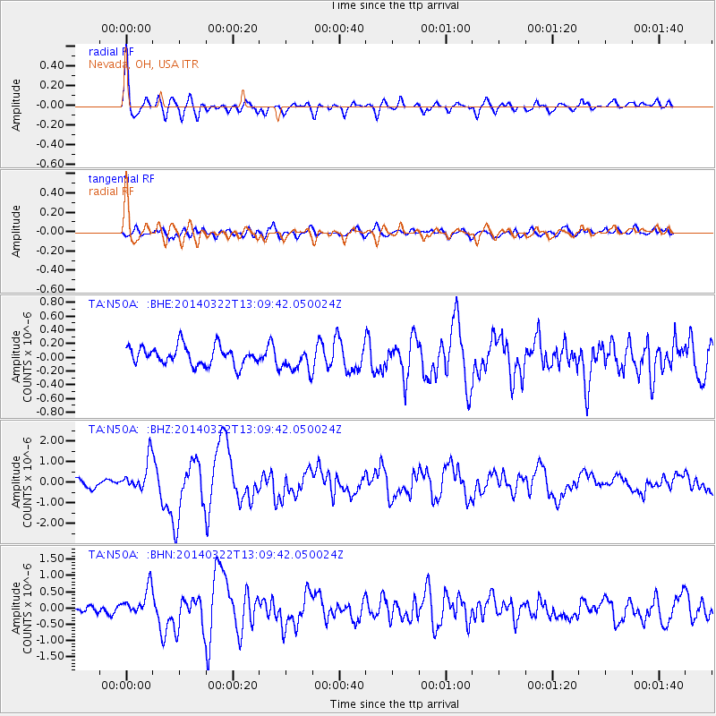
Signal To Noise
| Channel | StoN | STA | LTA |
| TA:N50A: :BHZ:20140322T13:09:42.050024Z | 4.270947 | 7.7822625E-7 | 1.82214E-7 |
| TA:N50A: :BHN:20140322T13:09:42.050024Z | 3.338711 | 4.26818E-7 | 1.2783914E-7 |
| TA:N50A: :BHE:20140322T13:09:42.050024Z | 1.2782995 | 1.7412337E-7 | 1.3621485E-7 |
| Arrivals |
| Ps | 3.7 SECOND |
| PpPs | 12 SECOND |
| PsPs/PpSs | 16 SECOND |


