You are here: Home > Network List > YT07 - POLENET Stations List
> Station MA04 Polenet mini-array MA04 > Earthquake Result Viewer
MA04 Polenet mini-array MA04 - Earthquake Result Viewer
| Earthquake location: |
Vanuatu Islands |
| Earthquake latitude/longitude: |
-17.0/168.5 |
| Earthquake time(UTC): |
2015/01/23 (023) 03:47:27 GMT |
| Earthquake Depth: |
218 km |
| Earthquake Magnitude: |
6.8 MWP, 6.9 MI, 7.0 MI |
| Earthquake Catalog/Contributor: |
NEIC PDE/NEIC COMCAT |
|
| Network: |
YT POLENET |
| Station: |
MA04 Polenet mini-array MA04 |
| Lat/Lon: |
78.42 S/97.59 W |
| Elevation: |
1725 m |
|
| Distance: |
74.2 deg |
| Az: |
167.913 deg |
| Baz: |
262.71 deg |
| Ray Param: |
0.051876158 |
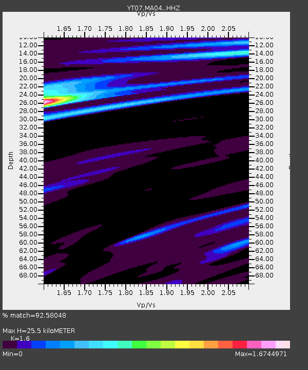
| Estimated Moho Depth: |
25.5 km |
| Estimated Crust Vp/Vs: |
1.60 |
| Assumed Crust Vp: |
5.833 km/s |
| Estimated Crust Vs: |
3.646 km/s |
| Estimated Crust Poisson's Ratio: |
0.18 |
|
| Radial Match: |
92.58048 % |
| Radial Bump: |
214 |
| Transverse Match: |
72.90835 % |
| Transverse Bump: |
400 |
| SOD ConfigId: |
3390531 |
| Insert Time: |
2019-04-16 03:46:21.722 +0000 |
| GWidth: |
2.5 |
| Max Bumps: |
400 |
| Tol: |
0.001 |
|

Signal To Noise
| Channel | StoN | STA | LTA |
| YT:MA04: :HHZ:20150123T03:58:08.438977Z | 10.9966345 | 2.9404314E-6 | 2.6739377E-7 |
| YT:MA04: :HHN:20150123T03:58:08.438977Z | 1.3757722 | 3.8820397E-7 | 2.8217167E-7 |
| YT:MA04: :HHE:20150123T03:58:08.438977Z | 4.4266386 | 9.807223E-7 | 2.2155014E-7 |
| Arrivals |
| Ps | 2.7 SECOND |
| PpPs | 11 SECOND |
| PsPs/PpSs | 14 SECOND |


