You are here: Home > Network List > TA - USArray Transportable Network (new EarthScope stations) Stations List
> Station R49A Shelbyville, KY, USA > Earthquake Result Viewer
R49A Shelbyville, KY, USA - Earthquake Result Viewer
| Earthquake location: |
Near Coast Of Northern Chile |
| Earthquake latitude/longitude: |
-19.8/-70.9 |
| Earthquake time(UTC): |
2014/03/22 (081) 12:59:59 GMT |
| Earthquake Depth: |
20 km |
| Earthquake Magnitude: |
6.2 MWW, 6.2 MWB, 6.3 MWC, 6.4 MWC |
| Earthquake Catalog/Contributor: |
NEIC PDE/NEIC COMCAT |
|
| Network: |
TA USArray Transportable Network (new EarthScope stations) |
| Station: |
R49A Shelbyville, KY, USA |
| Lat/Lon: |
38.29 N/85.17 W |
| Elevation: |
251 m |
|
| Distance: |
59.3 deg |
| Az: |
346.937 deg |
| Baz: |
164.304 deg |
| Ray Param: |
0.062265057 |
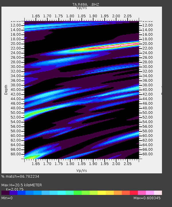
| Estimated Moho Depth: |
20.5 km |
| Estimated Crust Vp/Vs: |
2.02 |
| Assumed Crust Vp: |
6.498 km/s |
| Estimated Crust Vs: |
3.221 km/s |
| Estimated Crust Poisson's Ratio: |
0.34 |
|
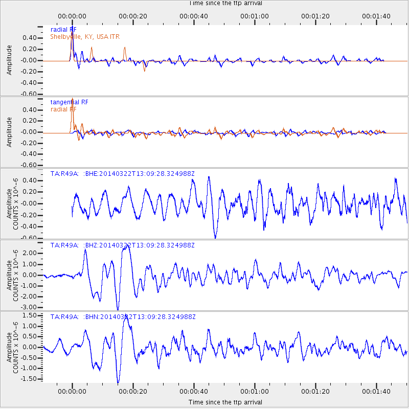
| Radial Match: |
86.782234 % |
| Radial Bump: |
363 |
| Transverse Match: |
61.408 % |
| Transverse Bump: |
400 |
| SOD ConfigId: |
626651 |
| Insert Time: |
2014-04-21 10:42:32.000 +0000 |
| GWidth: |
2.5 |
| Max Bumps: |
400 |
| Tol: |
0.001 |
|
Signal To Noise
| Channel | StoN | STA | LTA |
| TA:R49A: :BHZ:20140322T13:09:28.324988Z | 7.114045 | 9.3771246E-7 | 1.3181143E-7 |
| TA:R49A: :BHN:20140322T13:09:28.324988Z | 2.7286284 | 3.5947212E-7 | 1.3174096E-7 |
| TA:R49A: :BHE:20140322T13:09:28.324988Z | 1.0518652 | 1.5814558E-7 | 1.5034776E-7 |
| Arrivals |
| Ps | 3.4 SECOND |
| PpPs | 9.1 SECOND |
| PsPs/PpSs | 12 SECOND |


