You are here: Home > Network List > TA - USArray Transportable Network (new EarthScope stations) Stations List
> Station T49A Edmonton, KY, USA > Earthquake Result Viewer
T49A Edmonton, KY, USA - Earthquake Result Viewer
| Earthquake location: |
Near Coast Of Northern Chile |
| Earthquake latitude/longitude: |
-19.8/-70.9 |
| Earthquake time(UTC): |
2014/03/22 (081) 12:59:59 GMT |
| Earthquake Depth: |
20 km |
| Earthquake Magnitude: |
6.2 MWW, 6.2 MWB, 6.3 MWC, 6.4 MWC |
| Earthquake Catalog/Contributor: |
NEIC PDE/NEIC COMCAT |
|
| Network: |
TA USArray Transportable Network (new EarthScope stations) |
| Station: |
T49A Edmonton, KY, USA |
| Lat/Lon: |
37.10 N/85.53 W |
| Elevation: |
313 m |
|
| Distance: |
58.2 deg |
| Az: |
346.232 deg |
| Baz: |
163.718 deg |
| Ray Param: |
0.06295853 |
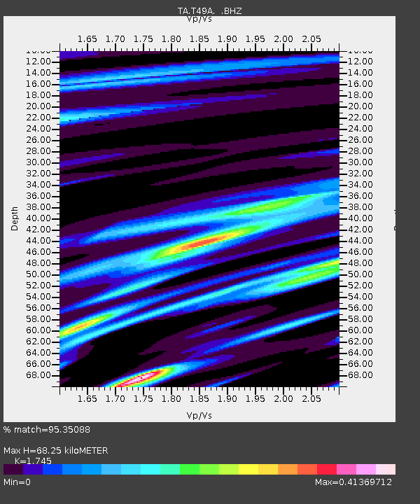
| Estimated Moho Depth: |
68.25 km |
| Estimated Crust Vp/Vs: |
1.75 |
| Assumed Crust Vp: |
6.476 km/s |
| Estimated Crust Vs: |
3.711 km/s |
| Estimated Crust Poisson's Ratio: |
0.26 |
|
| Radial Match: |
95.35088 % |
| Radial Bump: |
342 |
| Transverse Match: |
71.531265 % |
| Transverse Bump: |
400 |
| SOD ConfigId: |
626651 |
| Insert Time: |
2014-04-21 10:43:35.384 +0000 |
| GWidth: |
2.5 |
| Max Bumps: |
400 |
| Tol: |
0.001 |
|
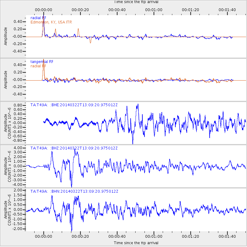
Signal To Noise
| Channel | StoN | STA | LTA |
| TA:T49A: :BHZ:20140322T13:09:20.975012Z | 6.83053 | 1.0985907E-6 | 1.6083536E-7 |
| TA:T49A: :BHN:20140322T13:09:20.975012Z | 4.6922803 | 5.0588596E-7 | 1.0781239E-7 |
| TA:T49A: :BHE:20140322T13:09:20.975012Z | 1.9651719 | 2.045423E-7 | 1.04083675E-7 |
| Arrivals |
| Ps | 8.3 SECOND |
| PpPs | 28 SECOND |
| PsPs/PpSs | 36 SECOND |


