You are here: Home > Network List > TA - USArray Transportable Network (new EarthScope stations) Stations List
> Station T50A Nancy, KY, USA > Earthquake Result Viewer
T50A Nancy, KY, USA - Earthquake Result Viewer
| Earthquake location: |
Near Coast Of Northern Chile |
| Earthquake latitude/longitude: |
-19.8/-70.9 |
| Earthquake time(UTC): |
2014/03/22 (081) 12:59:59 GMT |
| Earthquake Depth: |
20 km |
| Earthquake Magnitude: |
6.2 MWW, 6.2 MWB, 6.3 MWC, 6.4 MWC |
| Earthquake Catalog/Contributor: |
NEIC PDE/NEIC COMCAT |
|
| Network: |
TA USArray Transportable Network (new EarthScope stations) |
| Station: |
T50A Nancy, KY, USA |
| Lat/Lon: |
37.02 N/84.84 W |
| Elevation: |
302 m |
|
| Distance: |
58.0 deg |
| Az: |
346.835 deg |
| Baz: |
164.453 deg |
| Ray Param: |
0.06311078 |
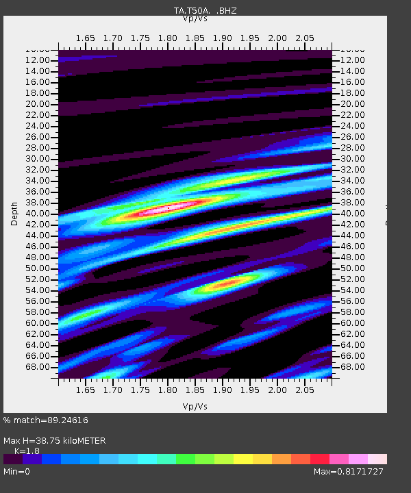
| Estimated Moho Depth: |
38.75 km |
| Estimated Crust Vp/Vs: |
1.80 |
| Assumed Crust Vp: |
6.476 km/s |
| Estimated Crust Vs: |
3.598 km/s |
| Estimated Crust Poisson's Ratio: |
0.28 |
|
| Radial Match: |
89.24616 % |
| Radial Bump: |
400 |
| Transverse Match: |
79.60825 % |
| Transverse Bump: |
400 |
| SOD ConfigId: |
626651 |
| Insert Time: |
2014-04-21 10:43:36.499 +0000 |
| GWidth: |
2.5 |
| Max Bumps: |
400 |
| Tol: |
0.001 |
|
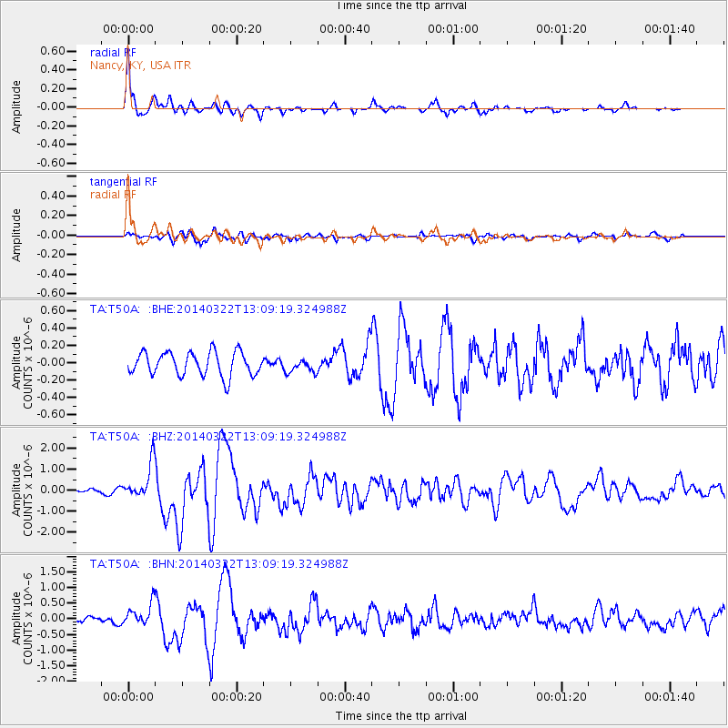
Signal To Noise
| Channel | StoN | STA | LTA |
| TA:T50A: :BHZ:20140322T13:09:19.324988Z | 6.602539 | 8.5337007E-7 | 1.2924878E-7 |
| TA:T50A: :BHN:20140322T13:09:19.324988Z | 4.3540297 | 3.4583903E-7 | 7.942964E-8 |
| TA:T50A: :BHE:20140322T13:09:19.324988Z | 0.59878963 | 8.0970636E-8 | 1.3522384E-7 |
| Arrivals |
| Ps | 5.0 SECOND |
| PpPs | 16 SECOND |
| PsPs/PpSs | 21 SECOND |


