You are here: Home > Network List > TA - USArray Transportable Network (new EarthScope stations) Stations List
> Station U40A Yellville, AR, USA > Earthquake Result Viewer
U40A Yellville, AR, USA - Earthquake Result Viewer
| Earthquake location: |
Near Coast Of Northern Chile |
| Earthquake latitude/longitude: |
-19.8/-70.9 |
| Earthquake time(UTC): |
2014/03/22 (081) 12:59:59 GMT |
| Earthquake Depth: |
20 km |
| Earthquake Magnitude: |
6.2 MWW, 6.2 MWB, 6.3 MWC, 6.4 MWC |
| Earthquake Catalog/Contributor: |
NEIC PDE/NEIC COMCAT |
|
| Network: |
TA USArray Transportable Network (new EarthScope stations) |
| Station: |
U40A Yellville, AR, USA |
| Lat/Lon: |
36.36 N/92.85 W |
| Elevation: |
374 m |
|
| Distance: |
59.6 deg |
| Az: |
339.486 deg |
| Baz: |
155.867 deg |
| Ray Param: |
0.0620846 |
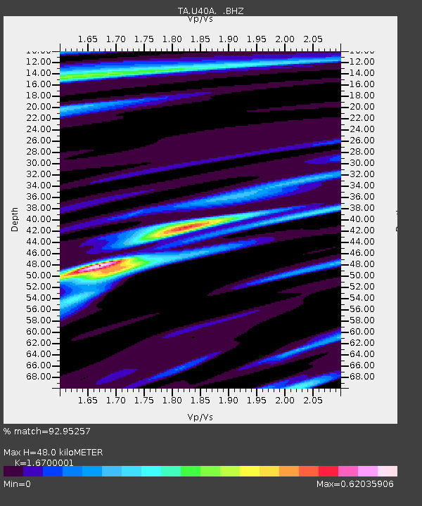
| Estimated Moho Depth: |
48.0 km |
| Estimated Crust Vp/Vs: |
1.67 |
| Assumed Crust Vp: |
6.53 km/s |
| Estimated Crust Vs: |
3.91 km/s |
| Estimated Crust Poisson's Ratio: |
0.22 |
|
| Radial Match: |
92.95257 % |
| Radial Bump: |
300 |
| Transverse Match: |
81.24779 % |
| Transverse Bump: |
400 |
| SOD ConfigId: |
626651 |
| Insert Time: |
2014-04-21 10:44:09.447 +0000 |
| GWidth: |
2.5 |
| Max Bumps: |
400 |
| Tol: |
0.001 |
|

Signal To Noise
| Channel | StoN | STA | LTA |
| TA:U40A: :BHZ:20140322T13:09:30.199988Z | 3.8816006 | 5.452126E-7 | 1.4046076E-7 |
| TA:U40A: :BHN:20140322T13:09:30.199988Z | 1.7655876 | 1.9829307E-7 | 1.12309955E-7 |
| TA:U40A: :BHE:20140322T13:09:30.199988Z | 1.3298646 | 1.1080323E-7 | 8.331917E-8 |
| Arrivals |
| Ps | 5.2 SECOND |
| PpPs | 19 SECOND |
| PsPs/PpSs | 24 SECOND |


