You are here: Home > Network List > TA - USArray Transportable Network (new EarthScope stations) Stations List
> Station U60A Pendleton, NC, USA > Earthquake Result Viewer
U60A Pendleton, NC, USA - Earthquake Result Viewer
| Earthquake location: |
Near Coast Of Northern Chile |
| Earthquake latitude/longitude: |
-19.8/-70.9 |
| Earthquake time(UTC): |
2014/03/22 (081) 12:59:59 GMT |
| Earthquake Depth: |
20 km |
| Earthquake Magnitude: |
6.2 MWW, 6.2 MWB, 6.3 MWC, 6.4 MWC |
| Earthquake Catalog/Contributor: |
NEIC PDE/NEIC COMCAT |
|
| Network: |
TA USArray Transportable Network (new EarthScope stations) |
| Station: |
U60A Pendleton, NC, USA |
| Lat/Lon: |
36.47 N/77.16 W |
| Elevation: |
8.0 m |
|
| Distance: |
56.2 deg |
| Az: |
353.907 deg |
| Baz: |
172.876 deg |
| Ray Param: |
0.06424504 |
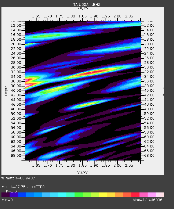
| Estimated Moho Depth: |
37.75 km |
| Estimated Crust Vp/Vs: |
1.60 |
| Assumed Crust Vp: |
6.565 km/s |
| Estimated Crust Vs: |
4.103 km/s |
| Estimated Crust Poisson's Ratio: |
0.18 |
|
| Radial Match: |
86.9437 % |
| Radial Bump: |
400 |
| Transverse Match: |
75.00723 % |
| Transverse Bump: |
400 |
| SOD ConfigId: |
626651 |
| Insert Time: |
2014-04-21 10:44:21.040 +0000 |
| GWidth: |
2.5 |
| Max Bumps: |
400 |
| Tol: |
0.001 |
|

Signal To Noise
| Channel | StoN | STA | LTA |
| TA:U60A: :BHZ:20140322T13:09:06.975012Z | 2.5417445 | 4.5677757E-7 | 1.7971027E-7 |
| TA:U60A: :BHN:20140322T13:09:06.975012Z | 1.1600349 | 2.445766E-7 | 2.1083555E-7 |
| TA:U60A: :BHE:20140322T13:09:06.975012Z | 1.3945429 | 2.8718472E-7 | 2.0593464E-7 |
| Arrivals |
| Ps | 3.7 SECOND |
| PpPs | 14 SECOND |
| PsPs/PpSs | 18 SECOND |


